Winter WX Advisory for Union,Henderson, and Daviess Counties for the New Years event. Much of Western KY and all of TN will remain all or mostly air rain, but these counties may get some minor ice accumulation before the changeover to rain.
Sunday, December 30, 2012
Winter WX Advisory for NW KY
http://forecast.weather.gov/
Winter WX Advisory for Union,Henderson, and Daviess Counties for the New Years event. Much of Western KY and all of TN will remain all or mostly air rain, but these counties may get some minor ice accumulation before the changeover to rain.
Winter WX Advisory for Union,Henderson, and Daviess Counties for the New Years event. Much of Western KY and all of TN will remain all or mostly air rain, but these counties may get some minor ice accumulation before the changeover to rain.
Friday, December 28, 2012
Heavy Snow
A very heavy snow band is moving along the Ohio River. Ballard, McCracken, Livingston, north Marshall, Crittenden Counties appear to be under the heaviest returns. Which could feature 1 inch a hour snowfall and maybe some lightning strikes.
Call map for tonight's winter event.

Update
Some models are showing the snow band tonight to be wider. Depending on how the temperatures go and how quick the changeover there is a chance all of Western KY and maybe even portions of Northwestern Middle TN could see measurable snow.
Winter Weather Advisory
A Winter Weather Advisory is in effect for areas along and north of the Western KY Parkway. 1 to 3 inches of snow is expected with some sleet mix. Better chances closer to the Ohio River.
Wednesday, December 26, 2012
Widespread Blizzard in Northwest and far West parts of KY
Most everyone is to snow. Remember if you are traveling from say Henderson KY to Benton KY to Mayfield KY westward don't. There is widespread blowing and drifting of the snow and blizzard conditions ongoing.
Tuesday, December 25, 2012
Links
http://www.radioreference.com/apps/audio/
^^Scanner Links^^
http://weatherobservatory.com/radar_grearth2.htm
^^ Radar Link^^
http://www.crh.noaa.gov/pah/
^^ NWS Paducah site^^
^^Scanner Links^^
http://weatherobservatory.com/radar_grearth2.htm
^^ Radar Link^^
http://www.crh.noaa.gov/pah/
^^ NWS Paducah site^^
The last update for the night
The event still looks to play out not like my morning thoughts, but more of my afternoon thoughts. Smithland to Mayfield to Fulton KY westward will be the big winners. The eastern edge of that band may reach to near or just west of LBL. Scattered snow showers towards daybreak will supply the snow for the areas east of LBL. Thinking 1-3 east of LBL and North Middle TN. It is a wait and see and surprises may occur. Even with only 1-3 inches of snow blowing and drifting of snow will be a major issue with 40-45MPH wind gusts. Travel is not recommended from later tonight into tomorrow. The event will start in far West KY in 2 hours and spread eastward towards daybreak.
Update
http://weatherobservatory.com/radar_grearth2.htm
A good radar for this event. Just because the snow amounts have been reduced(for areas east of LBL) there still will be issues with blowing and drifting of the snow that falls.
A good radar for this event. Just because the snow amounts have been reduced(for areas east of LBL) there still will be issues with blowing and drifting of the snow that falls.
I forgot the dry slot

HPC maps
The following are some links from the HPC which show the chances of the Winter Storm.
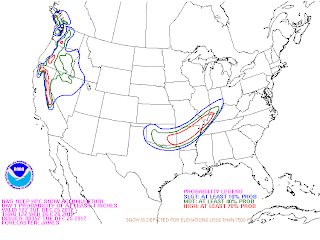
 The first map is the chance of receiving 4 or more inches of snow and the second one is the chance of receiving 8 or more inches of snow.


It is about to happen
Blizzard Warning for all of Western KY(Winter Storm Watch for Christian and Todd). We are looking at a plains style blizzard. As of now looking at 3 to 9 inches of snow across Western KY with a sharp cutoff somewhere around Eastern Christian/Todd/Logan Counties between the heavier snows and the rain/light snow mix. Areas in the snow band will experience 35-45MPH wind gusts, heavy snow fall rates, whiteout conditions, potential thunder and lightning, and a chance at power outages, drifts may reach several feet in areas that are prone to drifting.
Timing of the worst impacts will be from 10pm-8am.
Timing of the worst impacts will be from 10pm-8am.
Monday, December 24, 2012

Blizzard Watch
A Blizzard Watch has been put into effect for parts of Western KY. This is major guys, but still a very close call. The models have slid SE enough to where Blizzard Conditions are possible from a Henderson to Smithland to Paducah to Fulton line westward. Other areas of Western KY may cash in depending on model track.
Dense Fog Advisory for Western KY
http://forecast.weather.gov/showsigwx.php?warnzone=KYZ017&warncounty=KYC047&firewxzone=KYZ017&local_place1=&product1=Dense+Fog+Advisory
Winter Storm Watch
Breaking News a Winter Storm Watch is in effect for Fulton, Hickman, Carlislie, Ballard, McCracken, Livingston, Crittenden, Union, Henderson, and Webster Counties for the Christmas Night-26th storm
Thursday, December 20, 2012
High Wind threat
Wind gusts of 45-57MPH likely across Western Kentucky and 40-49 across Middle TN today. Travel will be hazardous with high profile vehicles, and there is potential for damage to Christmas Decorations and even some minor tree-powerline damage.
Sunday, December 9, 2012
Tornado Watch 677
TORNADO WATCH 677 IS IN EFFECT UNTIL 900 PM CST FOR THE
FOLLOWING LOCATIONS
KENTUCKY COUNTIES INCLUDED ARE
BALLARD CALLOWAY CARLISLE
FULTON GRAVES HICKMAN
LIVINGSTON MARSHALL MCCRACKEN
FOLLOWING LOCATIONS
KENTUCKY COUNTIES INCLUDED ARE
BALLARD CALLOWAY CARLISLE
FULTON GRAVES HICKMAN
LIVINGSTON MARSHALL MCCRACKEN
Wednesday, October 17, 2012
T-Storm Watch
T-Storm 669 till 2am for the rest of Western KY east of US 45. Areas along and west of US 45 are under a Tornado Watch.
Tuesday, October 16, 2012
Slight Risk of severe tomorrow.
There is a slight risk of severe weather across all of West KY and portions of far Northwest Middle Tennessee tomorrow evening and tomorrow night. This exists from a Parsons TN line to a Guthrie KY line westward. The strongest storms may contain damaging winds. In a highly sheared environment a brief funnel/tornado spin-up cannot be totally ruled out.
Sunday, October 14, 2012
Mayfield KY survey
http://forecast.weather.gov/
The Mayfield KY damage from this morning was caused by a tornado.
The Mayfield KY damage from this morning was caused by a tornado.
Wednesday, October 10, 2012
Sunday, September 23, 2012
Frost Possible
http://forecast.weather.gov/showsigwx.php?warnzone=KYZ017&warncounty=KYC047&firewxzone=KYZ017&local_place1&product1=Frost+Advisory
Frost Advisory just like with last night lows of 34-41 causing patchy frost in rural areas in West KY and NW Middle TN.
Frost Advisory just like with last night lows of 34-41 causing patchy frost in rural areas in West KY and NW Middle TN.
Monday, September 17, 2012
Im ready
Highs in the upper 60's tomorrow and lows tomorrow night into Wednesday morning will bottom out to the 38-44 range. I'm ready.
Friday, September 7, 2012
Severe Thunderstorm Watch
A cluster/line segment of storms is about to cross the Miss. River. Severe storms are possible with damaging winds of 58-70MPH being the main threat as the storms move through the area. Impacts will be felt along the Ohio River and MS River at around 9ish, and clear Western KY and NW Middle TN at around midnight, and press on towards the Nashville TN area after midnight. T-Storm Watch for West KY till midnight.
Saturday, September 1, 2012
Overview
An interesting first day of fall severe weather season. Reports of a brief tornado in far West McCracken county. Thankfully the damage in Ballard/McCracken counties is only tree/powerline type, and no injuries of any sort. Locally Heavy rain tonight. May be a strong storm in West Middle TN, but think the tornado threat is over for the night.
Tornado on the ground
Tornado report on the ground near Woodville KY moving towards the nw part of Paducah before going into Massac County IL. Take cover now in that area don't wait.
Severe update
Funnel Cloud in far north Ballard County 6 moving towards Bandana and Monkey's Eyebrow
region. Could produce a tornado at anytime.
Tornado Warning NW McCracken and Ballard County.
region. Could produce a tornado at anytime.
Tornado Warning NW McCracken and Ballard County.
Wednesday, August 29, 2012
Isaac Impacts?
The remnants of Isaac will move over Missouri then move across IL/IN/OH as a weak cold front picks the remnant system up. In far Western KY from along and west of US 45, and right along the Ohio River 1-3 inches of rain is possible. Locally more if heavier bands form, and localized flooding may occur under these heavier bands if they from. Elsewhere in Western KY and into Middle TN .75 to just under 2 inches of rain is in the forecast. Wind gusts of 30-35mph may cause issues on area lakes for a part of Labor Day Weekend. The heaviest rain chances are for Friday and Saturday.
Saturday, August 25, 2012
Good lake day
Very good lake day today. There is some scattered rain in Western TN and SE Missouri, but don't think that will negatively impact the lake day. Lake Day 4 out of 5 tomorrow as some isolated to scattered storm activity may occur, but still a nice day.
Friday, August 17, 2012
Thursday, August 16, 2012
Storm update
Those storms have weaken but still could contain 40-50MPH winds and vivid lightning which is dangerous for those out on the lakes.
Severe storm
Salem, Reidland, Smithland, Burna, Calvert City prepare for 59-70MPH winds with the storm moving towards you.
Monday, August 13, 2012
Update
All of Western KY and NW Middle TN is in a Slight Risk of severe weather this afternoon and tonight. Think that the best threat for severe storms will be along and west of US 45, as that is where things are more unstable.
Sunday, August 12, 2012
Interesting day possible
Watching out for the risk of severe storms during the day tomorrow. A few storms could go severe with damaging winds and large hail. There may even be enough low level shear for a brief tornado spinup. This isn't expected to be a widespread event, but could be interesting by August standards. How much cloudcover hangs around early will determine how much of a threat there is for strong to severe storms.
Wednesday, August 8, 2012
Better days ahead
Highs in the 96-99 range today. A cold front moves into the area tomorrow and causes chances of thunderstorms. Some storms could be severe with the best chances of severe weather in the Evansville Tri-State area. Nice weather for the weekend lows could get down into the upper 50's.
Saturday, August 4, 2012
Storm chances tomm.
Rain chances later tonight. Some thunder and lightning. A few storms may have damaging wind potential tomorrow afternoon. In Western KY this will occur from 11am-6pm and Middle TN in the afternoon-early evening hours. Lake Day a dismal 2 out of 5.
Thursday, July 26, 2012
A little busy
I'm a little busy with classwork in the next few weeks, so the post frequency has been down. There are some severe storms in the forecast tonight along with a Severe Thunderstorm Watch till 9pm. A few storms out of IL and MO will move into Western KY and a few may produce large hail and damaging winds.
Tuesday, July 17, 2012
Heat Advisory
Heat Advisory for Daviess, Union, and Henderson Counties today in Northwestern Kentucky. High humidity and temps in the 95-100 range will lead to heat index values at or above 105. 100-105 Heat Index values are expected for the rest of Western KY and into NW Middle TN.
Saturday, July 14, 2012
Lake Day Sunday
Lake Day 3 out of 5 same as today. Scattered storms with some areas having widespread activity. Beware of storms if you are going to be out on the lakes. Lightning and locally heavy rain in the strongest storms.
Steady rain moving
Steady rainfall from Paris Landing to Clarksville back towards Centerville and Nashville TN moving northward towards southern Kentucky. Watch out for locally heavy rain and lightning in the strongest storms. If you are on the lake stay in the lodge or an indoor facility till the storms pass.
Friday, July 13, 2012
Lake Day
Lake Day has been upped to a 3 out of 5. Thunderstorms will be more scattered instead of widespread. Some storms will contain locally heavy rain and vivid lightning, but not everyone will get the beneficial rain across NW Middle TN or Western KY.
Thursday, July 12, 2012
Lake Day 2 out of 5
Lake Day 2 out of 5. Jason isn't going to be the only issue out on the lakes tomorrow. Scattered to Widespread rainfall is likely across the LBL and Lake Malone areas tomorrow, assuming the boundary doesn't get held back in AL/S TN.
Drought
Portions of Union, Henderson, McCracken, and Ballard County have been upgraded to D4(exceptional drought). This is often the sign of a historical drought developing. These areas have also dodged a lot of the heavy rain the past week. Paducah KY has picked up 2.82 inches of rain since April 1st. They average 15.55 inches during that timeframe.
Wednesday, July 11, 2012
Helpful rain
Scattered storms today especially a Bardwell to Central City KY line southward into Tennessee. Widespread activity including heavy rains from Thursday-Saturday with scattered rain chances from Sunday into next week. Helpful rain.
Sunday, July 8, 2012
Today's overview
Still one more day of hot weather. Highs in the mid to upper 90's but humidity will produce 101-106 Heat Index values. Scattered storms also today. Lake Day 3 out of 5.
Saturday, July 7, 2012
More heat
Highs of 103-108 today in Western KY. Relief is coming and the Excessive Heat Warning ends tonight, so hopefully I won't have to talk about the heat for awhile.
Friday, July 6, 2012
Water Shortage Watch for parts of Western KY
http://www.indystar.com/article/B2/20120706/NEWS01/307060073/State-issues-water-shortage-watch-27-Kentucky-counties?odyssey=mod_sectionstories
This includes the Western Kentucky counties of Crittenden and Webster.
This includes the Western Kentucky counties of Crittenden and Webster.
Thursday, July 5, 2012
More High Heat
Excessive Heat Warning continues in Western KY and Heat Advisory for the western 2/3rds of Middle TN as temps. rise into the 100's.
Wednesday, July 4, 2012
Some Firework Shows have been cancelled
Breaking News: The Western Kentucky State Fair has cancelled the fireworks show. No fireworks in Christian County. This is another addition to the list of counties and cities that have cancelled their firework shows which include Muhlenberg and Todd Counties and the city of Springfield in Middle Tennessee.

Sunday, July 1, 2012
Water Restrictions
- Clarksville TN is now under a Water Restriction
I haven't heard of any in Western KY, but Muhlenberg County has asked residents to voluntary conserve water, and everyone in Western Kentucky needs to voluntary conserve water.
I haven't heard of any in Western KY, but Muhlenberg County has asked residents to voluntary conserve water, and everyone in Western Kentucky needs to voluntary conserve water.
Saturday, June 30, 2012
3 out of 5 lake day
3 out of 5 Lake Day for Sunday. Excessive Heat Warning for Western Kentucky and Heat Advisory for Middle Tennessee. A slight chance of storms may occur east of the lakes.
Friday, June 29, 2012
Voluntary Order from Muhlenberg County
Muhlenberg County is now asking residents to voluntary limit their water usage, and for people to limit car washing, filling up pools, and watering yards and to overall conserve water, so that water restrictions won't have to go out.

Lake Day 3 out of 5.
I forgot to do this because of all the activity with the fires and stuff. Lake Day will only be 3 out of 5 today due to the Excessive Heat.
Excessive Heat Warning
http://forecast.weather.gov/showsigwx.php?warnzone=KYZ017&warncounty=KYC047&firewxzone=KYZ017&local_place1=Hopkinsville+KY&product1=Excessive+Heat+Warning
Breaking News!! Excessive Heat Warning for Western Kentucky through Sunday.
Breaking News!! Excessive Heat Warning for Western Kentucky through Sunday.
Thursday, June 28, 2012
This is history!!! This is heat!! This is heat history!!
I fully expect temperatures in the 110-112 range in some places in Western/Central KY tomorrow. This will be historic. Tomorrow will be the hottest day of this heat wave and could be one of the hottest days ever.
Another update on North Christian
News 5 reports that progress is being made on the North Christian fire. No structures have been destroyed. Fire crews many volunteer will be in rotation to try and prevent any hotspots from redeveloping.
Another update
Reports are that the wildfire in North Christian is under control. Other fires are burning near Dawson Springs and parts of LBL. Don't know about the status of those, but at least with the winds calming down it will be easier to control those.
Crofton KY fire update
The wildfire is mostly on the west side of the Pennyrile Parkway. Evacuations are occurring along Lewis and Grapevine Roads. More updates tonight or early tomorrow as they come. Got this information from posters on facebook that are in the area.
Christian County fire
Also fires reported in Caldwell and Hopkins County.
CHRISTIAN COUNTY, KY.- A grass fire in Christian County has endangered several homes and businesses.
Officials with the Kentucky Transportation Cabinet said that the fire began just before 5 p.m. in the area on Pennyrile Parkway. The roadway was closed in both directions while crews tried to put out the blaze. Large amounts of smoke from the fire created a visibility problem for many drivers in the area. Traffic was rerouted and exited off between the 22 and 30 mile marker, drivers were urged to take US 41 as an alternate route.
Christian County 911 officials reported several homes and businesses are in the line of fire but not on fire as of 5:30 p.m.
Nine fire departments were called to fight the fire including the City of Hopkinsville and eight volunteer fire departments. Inmates from the County Jail were also brought out to assist fighting the blaze.
No word on how large the fire was.
Hot
The 1pm measurements
Henderson- 100
Ft. Campbell- 99
Paducah- 98
Greenville- 103
Madisonville- 104
Henderson- 100
Ft. Campbell- 99
Paducah- 98
Greenville- 103
Madisonville- 104
We don't like it this hot.

From Livingston County
EXECUTIVE ORDER
Livingston County, Kentucky
Due to the recent drought throughout Livingston County and the current Fire Watch Hazard, a NO-BURN order will be in effect beginning 1:00 pm Central Time, June 26th, 2012 for all of Livingston County.
This ban will remain in effect until the County experiences a significant rainfall or until such ban is removed by the County Judge/Executive.
Those intending to have Fire Work displays, please contact the County Judge Executive’s Office and take all necessary precautions in the prevention of unintended fires. The County is recommending individuals refrain from using fireworks at this time.
Chris Lasher, Livingston County Judge/Executive
June 26, 2012
Wednesday, June 27, 2012
Overview of the drought and heat.

More Burn Bans are very likely, and I will update as they come out.
Heat Safety Link
http://www.crh.noaa.gov/news/display_cmsstory.php?wfo=pah&storyid=84756&source=0
Heat Safety tips very important.
Heat Safety tips very important.
Freedom Fest postponed.
Muhlenberg County has just postponed Freedom Fest which is the annual festival/fireworks show they have for the 4th of July due to the drought and wildfire threat.
Tuesday, June 26, 2012
All Time-Record Heat!!! Old Generational Records will fall.
As someone who doesn't like heat this post this forecast isn't going to make me happy, and for people who are planning on celebrating the weekend before the 4th it will not make many happy. To put it bluntly an all-time record setting and intense heat wave that could rival anything we have ever seen before (especially in late June-early July) is expected to strike Western Kentucky and surrounding areas of the Midwest, Southeast, and Mid-Atlantic. Warm winds blowing down the Appalachians, a major SE Missouri Drought Ridge, and the merging of major drought zones across the USA and Mexico will lead to a historical dry heat wave. This heat wave will being on Thursday and continue and peak Friday and into Saturday. The heat will not let up well into next week and possibility even into the 4th of July.
Some possible temperature ranges:
Wickliffe KY
Thursday: 105-109
Friday: 106-110
Saturday: 103-107
Sunday: 103-106
Monday: 101-105
Paducah KY
Thursday: 101-105
Friday: 103-107
Saturday: 102-106
Sunday: 101-105
Monday: 100-104
Henderson KY
Thursday: 100-105
Friday: 102-106
Saturday: 99-102
Sunday: 97-102
Monday: 97-102
Hopkinsville KY
Thursday: 98-103
Friday: 102-107
Saturday: 101-106
Sunday: 97-102
Monday: 97-102
Paris TN
Thursday: 98-103
Friday: 102-106
Saturday: 101-105
Sunday: 99-103
Monday: 97-102
Concerns
- Increased wildfire activity due to extreme heat, and very dry ground. Burn bans are in effect for several Western Kentucky counties. Contact your county before you burn things.
- Although this is a dry heat temperatures in many areas will be in the 100's for at least 4-5 days in a row. This will cause stress especially on the elderly and the disabled who are more vulnerable to heat.
- This heat will cause even more evaporation on already dry soils. Leading to the drought getting worse. I fully expect some D4 exceptional drought to appear in Western Kentucky in future drought outlooks if this continues.
- With all the 4th of July events like the Western Kentucky State Fair in Hopkinsville and Glory Days in Mayfield it is important for event managers and event goers to pay attention to the signs of heat exhaustion and heat stroke, and stay hydrated.
Saturday, June 23, 2012
Burn Ban
Five counties have burn bans in effect. Crittenden, Henderson, Hopkins, Mclean, and Muhlenberg counties. Burning debris, grilling, camp fires, and charcoal grilling are prohibited. Fireworks may also be prohibited. There have been several reports of fires in southwest Indiana.
Thursday, June 21, 2012
Lake Day 5 out of 5
Lake Day 5 out of 5. Any rain chances(which are very slim anyway) should taper off by early morning. Leading to a nice day with temps in the low to mid 80's.
Drought update
http://droughtmonitor.unl.edu/DM_state.htm?KY%2CMW
A horrible development has occurred in the drought monitor. The addition of D3(extreme drought) has been given to much of Western Kentucky. This is the 2nd highest drought classification and represents a very high impact event. Agriculture will start taking a big heat, wildfire danger will increase, and thoughts about water restrictions may occur. This extreme drought extends from Murray KY to Cadiz KY to the Pennyrile forest to Henderson KY line westward. This includes all of the Purchase and all of the Flurospar district. A thin stripe of severe drought(slight less intense than extreme, but still could have bad impacts) surrounds the extreme drought. The Hopkinsville-Bowling Green KY area up to Lake Malone is only in D1(moderate drought) due to getting more relief, but despite that rain relief is still feeling some drought impacts.
A horrible development has occurred in the drought monitor. The addition of D3(extreme drought) has been given to much of Western Kentucky. This is the 2nd highest drought classification and represents a very high impact event. Agriculture will start taking a big heat, wildfire danger will increase, and thoughts about water restrictions may occur. This extreme drought extends from Murray KY to Cadiz KY to the Pennyrile forest to Henderson KY line westward. This includes all of the Purchase and all of the Flurospar district. A thin stripe of severe drought(slight less intense than extreme, but still could have bad impacts) surrounds the extreme drought. The Hopkinsville-Bowling Green KY area up to Lake Malone is only in D1(moderate drought) due to getting more relief, but despite that rain relief is still feeling some drought impacts.
Sunday, June 17, 2012
Non-severe Storms
There are storms in and around the LBL area. If you are in the LBL area and hear thunder get out of the water and seek shelter, so that you don't risk getting struck by lightning.
Saturday, June 16, 2012
Lake Update
Lake Day 4 out of 5 again tomorrow. Same as today/yesterday. Sunny and nice for most, but could get an isolated shower or thunderstorm.
Thursday, June 14, 2012
Drought Update
http://droughtmonitor.unl.edu/DM_state.htm?KY%2CMW
The latest Kentucky drought monitor has D2(severe drought) extending into Henderson/Webster Counties. D1 moderate drought and D0 abnormally dry remain about the same from last week in Western Kentucky. Burn bans remain in effect in Crittenden/Henderson counties.
The latest Kentucky drought monitor has D2(severe drought) extending into Henderson/Webster Counties. D1 moderate drought and D0 abnormally dry remain about the same from last week in Western Kentucky. Burn bans remain in effect in Crittenden/Henderson counties.
Monday, June 11, 2012
Saturday, June 9, 2012
Lake Day
Great lake day and rain chances should hold off till the pre-dawn hours for SW Kentucky and Northwest Middle TN. Tomorrow's lake day forecast is dismal. Lake Day 3 out of 5 on the KY side and 2 out of 5 on the TN side due to clouds and locally heavy rain with lightning possible
Thursday, June 7, 2012
Tuesday, June 5, 2012
Transit of Venus
http://www.msnbc.msn.com/id/47675548/ns/technology_and_science-space/?ocid=ansmsnbc11'
Transit of Venus is this afternoon starting at around 5pm central time for KY and TN.
Transit of Venus is this afternoon starting at around 5pm central time for KY and TN.
Monday, June 4, 2012
T-Storm Warning
Anyone doing night fishing in Camp Energy, and along the KY lake in Western KY needs to head indoors. This storm may have 50-60 MPH wind gusts and Quarter sized hail along with vivid lightning.
THE NATIONAL WEATHER SERVICE IN PADUCAH HAS ISSUED A
* SEVERE THUNDERSTORM WARNING FOR...
NORTH CENTRAL CALLOWAY COUNTY IN WESTERN KENTUCKY...
SOUTHERN LYON COUNTY IN WESTERN KENTUCKY...
EASTERN MARSHALL COUNTY IN WESTERN KENTUCKY...
WEST CENTRAL TRIGG COUNTY IN WESTERN KENTUCKY...
* UNTIL 1030 PM CDT.
Some storms
A few strong to severe storms are approaching Western KY. Although widespread severe isn't expected a few storms may pulse up to severe limits(nickel to quarter sized hail and 50-60MPH) throughout the evening and early overnight hours across Middle TN and Western KY.
T-Storm Watch 353
http://www.spc.noaa.gov/products/watch/ww0353.html
A little uncertain on how much severe threat is there in Western KY, but some storms may produce damaging winds/large hail.
A little uncertain on how much severe threat is there in Western KY, but some storms may produce damaging winds/large hail.
Saturday, June 2, 2012
22 years ago
http://www.crh.noaa.gov/news/display_cmsstory.php?wfo=pah&storyid=52435&source=2
Even though this spared Western Kentucky. The NWS of Paducah has provided an interesting history on this High Risk Day back 22 years ago that hit IL,IN,North KY, and portions of OH very hard. Features old SPC text and watch products.
Even though this spared Western Kentucky. The NWS of Paducah has provided an interesting history on this High Risk Day back 22 years ago that hit IL,IN,North KY, and portions of OH very hard. Features old SPC text and watch products.
4 out of 5 lake day
4 out of 5 lake day. Only reason it isn't a 5 out of 5 is it may still be a little too cool to swim. A good day.
Thursday, May 31, 2012
Lake Day forecast for weekend #2
Friday(6/1): Lake Day forecast of 2 out of 5. The day will start off cloudy with on and off drizzle. Temperatures for this first day of June won't get out of the 60's more than likely. The only good thing is that we will start to clear out the clouds later in the day. Not much you can do as far as swimming goes with temperatures in the 60's. Seattle like days don't equal good like days at all.
Saturday: (6/2) Lake Day forecast 5 out of 5: Starts off cool warms to at or just below 80. Mostly sunny skies and much improved compared to Friday.
Sunday: (6/3) Lake Day forecast 4 out of 5: The daytime portion of Sunday will be nice with temps. in the 80's and sunny skies. Storm activity may form at nightfall.
Wednesday, May 30, 2012

Sunday, May 27, 2012
95 years ago today.
Today is the 95th anniversary of the 5/27/1917 outbreak. This is the deadliest tornado outbreak in Western KY history. 68 fatalities and over 370 injuries occurred as two deadly tornadoes(one F-4 and another F-2) ripped across the Jackson Purchase counties of Fulton, Hickman, Carlisle, and Graves. The F4 that moved from Hickman KY to the southeast side of Clinton KY and ended near the Fancy Farm KY area was responsible for 65 of the 68 Western Kentucky fatalities. 33 fatalities occurred in Western and Middle Tennessee during this outbreak. The previous day featured 101 fatalities (the same number that occurred in Kentucky/Tennessee on the 27th) occurred in Missouri and Illinois.
Lake Day
5 out of 5 lake day today and 4 out of 5 tomorrow(due to late isolated thunderstorms tomorrow.)
Friday, May 25, 2012
Hot Saturday
Tomorrow's Highs across Western KY and NW Middle TN. Barlow KY: 100 Hopkinsville KY: 96
Paducah: 96-97 Henderson: 96 Murray: 96 Clarksville TN: 96 Big Sandy TN: 94
Thursday, May 24, 2012
Lake Day updated
Subject to be updated:
Saturday 5/26/2012- 5 out of 5
Sunday 5/27/2012- 5 out of 5
Memorial Day 5/28/2012- 4 out of 5
Heat could be an issue, but Heat Index values will stay under 100. Don't think with the ridge that much rain will form this weekend at all, but some chances of rain may appear late Memorial Day. A very isolated chance of rain may threaten NW KY on Friday, but shouldn't impact LBL or Lake Malone.
Lake Day Overview
Lake Day Forecast!!!!
The lake day forecast is where we examine the forecast and the weather models and come up with a rating from 1 to 5 on what type of day it will be weather wise for those who venture out on the lakes.
The Scale:
5: Great Lake Day (Get out and enjoy, still watch for any stray surprise t-storm that may of not been forecasted.)
4: Good Lake Day (Get out and enjoy, but watch for any hazard. These days are usually days that would be 5 out of 5 lake days except for isolated storm chances, or lingering cloudcover.)
3: Decent Lake Day (A little bit more iffy, still can be a good lake day, but usually storms are a bit more widespread, or it is excessively hot, or it is a nice sunny day that is pretty windy, or a combination.)
2: Poor Lake Day (Probably best to stay at home, but you can venture out. Usually days that could be washouts, or days which may feature some widespread severe weather actions, or 50MPH+ non-thunderstorm wind gusts, or a combination.)
1: Miserable Lake Day (It is best to stay at home or in the cabin during these days, these are your washout days, or days where there is a very high risk of widespread damaging wind/tornado events.)
What lakes/bodies of water does the Lake Day Forecast cover?
The lake day forecast covers the two main lakes in Western Kentucky and Northwest Middle Tennessee. The LBL area(portions of Livingston,Lyon,Marshall,Calloway,and Trigg Counties in Kentucky, and portions of Henry, Houston,Stewart,Humphries,and Benton counties in Tennessee) and Lake Malone(portions of Muhlenberg, Todd, and Logan counties in Kentucky). This includes places on LBL like Big Sandy, Venture River Water Park, Paris Landing, Energy Lake, and up towards Grand Rivers. Upon personal request I will be glad to check the forecast/models/or radar for any lake in Kentucky or Tennessee. On the 4th of July in particular areas along rivers like the Ohio, Mississippi, and Cumberland that run along Western KY and Middle TN will also be monitored, because a lot of 4th of July events occur along these major rivers.
When does the Lake Day Forecast come out?
The night before a designated lake day, and will be updated in the morning-midday hours of the lake day. A designated lake day is any Friday, Saturday, or Sunday from Memorial Day Weekend to Labor Day Weekend, and also the holidays of Memorial Day, 4th of July, and Labor Day.
An example Lake Day Forecast
Thursday Night an overview comes out. Let's pretend this is a random June day. The overview will be where I assign the first values for the whole week. Then each night, and again that morning I will update as needed.
Thursday Night Overview: (This is a Pretend Example)
Friday- Lake Day 4 out of 5: An isolated threat of non-severe thunderstorms and winds may increase overnight, but overall a good lake day.
Saturday- Lake Day 2 out of 5: Scattered to widespread thunderstorms with the threat of widespread damaging winds, both non-thunderstorm and thunderstorm.)
Sunday- Lake Day 5 out of 5: Nice temps around 90 with abundant sunshine and calm winds.
Factors that are taken into account:
Precipitation: No or very little chance of thunderstorms, which can contain lightning or gusty winds, which are dangerous to lake goers. Any risk of organized severe weather(Especially a SPC Moderate or High Risk) will negatively impact the lake day forecast greatly.
CloudCover: Days that are sunny or mostly sunny just make better lake days. Cloudcover can impact things like fishing.
Wind Speed: Days with wind gusts of over 35MPH can cause problems operating craft and boats on the water.
Temperature: We want the Heat Index, which is what the temperature feels like to your body when you factor in the humidity, to be between 72-104. If it goes below 72 it is a too cool for a lot of people to want to be at the lakes, and if it hits 105 or above the risk of heat exhaustion and even heat stroke goes up.
Factors that aren't taken into account, but still need to be watched for:
This is just for the weather on that day. The lake day forecast doesn't take into account long range climate(like droughts and the aftereffects of flooding.) The lake day forecast doesn't take into account Geological, Biological, and Man-Made impacts that aren't weather related. Still these are things you should still watch out for.
Flood impacts: Not a problem in 2012, but was in 2010 and 2011 watch out for flood damaged areas, areas at risk of mass wasting(mudslides, rock falls, etc..) Any flooded out structures may prose a hazardous creature or bacteria threat.
Drought impacts: Watch out in dry periods like we are facing heading into Memorial Day weekend here in 2012. Low water areas are a concern in drought. Also wildfire danger when you have hot days and dry vegetation is a major concern. Monitor all campfires and respect all potential burn-bans.
Biological factors: Watch out for ticks and mosquitoes and be prepared for them. Beware of live animals on the road, and always keep an eye on snakes. Four species of venomous snakes inhabit the LBL area.
Earthquakes: This one may seem a little strange to include, but LBL is in the line of fire if the big quake occurs. Having a major earthquake occur, and that quake would occur on a weekend between Memorial Day Weekend and Labor Day weekend is very rare statistically, but there is always that threat. With that being said it is a good idea to have an idea to know in the event of an earthquake just in case.
Man Made Impacts: There are some things that humans can do to that can make a 5 out of 5 lake day into a 1 out of 5 lake day. Any road construction is something you should watch and respect. Don't leave valuables unintended as there is always the threat of thieves. Respect burn-bans, and under no circumstances do not throw chert into the campfire. Another word of advice is to keep the drama at home. Starting drama can lead to fights, loss of friendships, the potential of getting in trouble with the law, and of course turn a good lake day into a nightmare. Also drama makes the citizens of Kentucky and Tennessee look bad to out of state visitors. We want to show everyone that isn't from this area that we can have a good time, and still have southern charm. I don't believe in judging or telling people how to live, because that is not my place to do so, but I do want people to realize that every decision has a consequence whether good or bad.
Disclaimer:
When making important decisions involving the lakes remember to go to the experts the National Weather Service which is linked below. The Lake Day Forecast is a guide, but it shouldn't be used in place of the National Weather Service, the US forest service, USGS, or other major Governmental agencies responsible for making the water ways of Western Kentucky and Northwest Middle TN enjoyable.
Lake Wind Advisory today
http://forecast.weather.gov/showsigwx.php?warnzone=KYZ017&warncounty=KYC047&firewxzone=KYZ017&local_place1=2+Miles+SSW+Hopkinsville+KY&product1=Lake+Wind+Advisory
Hot times are coming
http://www.crh.noaa.gov/pah/?n=heatpresentation
Beware of heat as temperatures rise into the mid to upper 90's this weekend. With dewpoints only in the low 60's the Heat Index values should stay under 100.
Beware of heat as temperatures rise into the mid to upper 90's this weekend. With dewpoints only in the low 60's the Heat Index values should stay under 100.
Sunday, May 20, 2012
Wednesday, May 16, 2012
Monday, May 7, 2012
River Flooding 2011 Overview
http://www.nws.noaa.gov/os/assessments/pdfs/MisssissippiRiverFloods12.pdf
Check out this assessment of the River Flooding from last year.
Check out this assessment of the River Flooding from last year.
Friday, May 4, 2012
Watch
Watch is likely across Western KY esp. the Coalfields area where damaging winds and large hail may occur.
http://www.spc.noaa.gov/products/md/md0693.html
http://www.spc.noaa.gov/products/md/md0693.html
http://ngmdb.usgs.gov/ngmdb/ngm_PNsearch.html
Used for Geologic Maps. TN's don't show up but the quadrangles in KY show up. I've been looking at some from portions of Lyon, Trigg, Christian, Todd, and Union counties.
Used for Geologic Maps. TN's don't show up but the quadrangles in KY show up. I've been looking at some from portions of Lyon, Trigg, Christian, Todd, and Union counties.
Saturday, April 28, 2012
Sunday, April 22, 2012
http://www.nws.noaa.gov/com/weatherreadynation/force.html
1 year ago the late April Tornadofest began. Starting with the Poole KY(Webster/Henderson county EF-2 Tornado, and St. Louis area tornadoes) and ending with the devastating tornado outbreak across MS, AL, TN, VA, GA that was April 27th.
1 year ago the late April Tornadofest began. Starting with the Poole KY(Webster/Henderson county EF-2 Tornado, and St. Louis area tornadoes) and ending with the devastating tornado outbreak across MS, AL, TN, VA, GA that was April 27th.
Frost
http://forecast.weather.gov/showsigwx.php?warnzone=KYZ017&warncounty=KYC047&firewxzone=KYZ017&local_place1=Hopkinsville+KY&product1=Special+Weather+Statement
Frost possible. Lows in the mid 30s across West KY and Mid TN.
Frost possible. Lows in the mid 30s across West KY and Mid TN.
Wednesday, April 11, 2012
Freeze Warning
Freeze Warning for all of Western KY and Middle TN. Temps will fall to below freezing(30-32). You need to protect crops and plants now.
Tuesday, April 10, 2012
Freeze Watch
Freeze Watch for Union, Henderson, and Daviess counties for tomorrow night. 31-33 temp. expected in this region with a temp f 32-36 expected elsewhere across Western KY. Sensitive crops and plants may not do well in when exposed to these condition's.
Friday, April 6, 2012
Easter
Easter High Temperatures for Western KY:
Henderson: 68
Hopkinsville: 69
Murray: 71
Paducah: 71
Sunny and perfect Easter weather. Morning temps are expected to be around 50.
Henderson: 68
Hopkinsville: 69
Murray: 71
Paducah: 71
Sunny and perfect Easter weather. Morning temps are expected to be around 50.
Saturday, March 31, 2012
Friday, March 30, 2012
Friday
An overall nice day. A few storms that form in Western Kentucky could contain large hail and damaging winds, but such storms should stay isolated.
Wednesday, March 28, 2012
Saturday, March 17, 2012
Some severe today
Slight Risk of Severe Weather for Western KY or from a Paris TN to Oak Grove KY line northward. Some storms may produce large hail and damaging winds today. A setup like we had during the week with the hail events.
Saturday, March 10, 2012
Spring Forward
Spring forward tonight also make sure you check your batteries on your NOAA Weather Radio, it will need to have a fresh set of batteries for the rest of this spring.
Friday, March 9, 2012
Tornadoes of Western KY so far
https://www.facebook.com/photo.php?fbid=291421967593491&set=a.152458704823152.37854.141426302593059&type=1&theater
From NWS Paducah facebook page.
So far this year eleven tornado tracks have been confirmed across Western KY.
By Outbreak they are
Hazel KY area(Southern Calloway County) EF-1: Early on Jan 23rd
Clifty KY area(Northern Todd County) EF-0: Early on Jan 23rd
Bandana KY(North of La Center) into Ragland(Ballard into Northwest McCracken Counties) EF-2 with 5 injuries: Leap Day Outbreak
North Side of Henderson Kentucky (Northern Henderson County) EF-1: Leap Day Outbreak
Madisonville Kentucky(Hopkins County) EF-0: Leap Day Outbreak
Southeast Side of Greenville Kentucky to Cleaton KY (Muhlenberg County) EF-2 1 injury: Leap Day Outbreak
Southwest Side of Greenville Kentucky (Muhlenberg County) EF-1: Leap Day Outbreak
North of Morganfield KY ( Northern Union County) EF-2 1 injury: March 2nd Tornado Outbreak
Southeast of Morganfield (Southeastern Union County) EF-0: March 2nd Tornado Outbreak
Southern Henderson County EF-0: March 2nd Tornado Outbreak
Southeast side of Owensboro KY (Eastern Daviess County) EF-0: March 2nd Tornado Outbreak.
Thursday, March 8, 2012
Union County KY tornado
http://www.crh.noaa.gov/news/display_cmsstory.php?wfo=pah&storyid=80052&source=0
EF-2 Tornado confirmed in Union County KY from the March 2nd Severe event.
EF-2 Tornado confirmed in Union County KY from the March 2nd Severe event.
Flash Flood Warning
THE NATIONAL WEATHER SERVICE IN PADUCAH HAS ISSUED A
* FLASH FLOOD WARNING FOR...
SOUTHERN CALDWELL COUNTY IN WESTERN KENTUCKY...
CALLOWAY COUNTY IN WESTERN KENTUCKY...
CARLISLE COUNTY IN WESTERN KENTUCKY...
CHRISTIAN COUNTY IN SOUTH CENTRAL KENTUCKY...
FULTON COUNTY IN WESTERN KENTUCKY...
GRAVES COUNTY IN WESTERN KENTUCKY...
HICKMAN COUNTY IN WESTERN KENTUCKY...
SOUTHERN HOPKINS COUNTY IN NORTHWEST KENTUCKY...
LYON COUNTY IN WESTERN KENTUCKY...
SOUTHEASTERN MCCRACKEN COUNTY IN WESTERN KENTUCKY...
MARSHALL COUNTY IN WESTERN KENTUCKY...
MUHLENBERG COUNTY IN SOUTH CENTRAL KENTUCKY...
TODD COUNTY IN SOUTH CENTRAL KENTUCKY...
TRIGG COUNTY IN WESTERN KENTUCKY...
Ponding of roads
http://forecast.weather.gov/showsigwx.php?warnzone=KYZ017&warncounty=KYC047&firewxzone=KYZ017&local_place1=Hopkinsville+KY&product1=Flood+Advisory
Flood Advisory watch out for ponding on the roads in Western KY from a Bardwell to Princeton to Crofton to Lake Malone KY line southward.
Flood Advisory watch out for ponding on the roads in Western KY from a Bardwell to Princeton to Crofton to Lake Malone KY line southward.
Wednesday, March 7, 2012
Links and info about the past two outbreaks.
http://www.crh.noaa.gov/news/display_cmsstory.php?wfo=pah&storyid=80298&source=0
http://www.crh.noaa.gov/news/display_cmsstory.php?wfo=pah&storyid=79781&source=0
http://www.crh.noaa.gov/news/display_cmsstory.php?wfo=pah&storyid=79781&source=0
Sunday, March 4, 2012
Today's weather
Red Flag Warning for SW and far West KY today, and a chance for a dusting to 1 inch of snow tonight in portions of NW KY
Friday, March 2, 2012
Overview
Prayers to those hit hard in Southern Indiana, Central KY/Eastern KY, and portions of TN/AL. No fatalities have been reported in Western KY, but some damage(wind or tornado) has been reported around Madisonville/Bremen,and possible tornado touchdowns in Webster, Henderson, and Daviess counties. Storm surveyors will be out to determine whether damaging winds or tornadoes were involved.
Outbreak likely update
http://www.spc.noaa.gov/products/outlook/day1otlk.html
High Risk of Severe Weather from Gracey KY to Sebree KY line East. Moderate Risk elsewhere. Severe WX outbreak likely a High Risk Tornado threat of 4 out of 5 east of that line other thoughts don't change
High Risk of Severe Weather from Gracey KY to Sebree KY line East. Moderate Risk elsewhere. Severe WX outbreak likely a High Risk Tornado threat of 4 out of 5 east of that line other thoughts don't change
Links
http://www.crh.noaa.gov/pah/
http://www.srh.noaa.gov/ohx/
Use these pages and local media to monitor storms today. I will be busy till 2:30pm so will able to track later parts of this event. You can refresh these pages to get the latest warnings, and plus they are straight from the NWS.
http://www.radioreference.com/apps/audio/?ctid=1012 -Christian County spotter feed.
http://www.radioreference.com/apps/audio/?ctid=1006 - Calloway County spotter feed.
http://www.radioreference.com/apps/audio/?ctid=1061 - McCracken County spotter feed.
http://www.radioreference.com/apps/audio/?ctid=1077
- Muhlenberg County spotter feed.
http://www.radioreference.com/apps/audio/?ctid=1039
- Henderson County spotter feed.
- Spotter feeds are above.

Message to school kids.
Anyone with relatives in school or school students follow the order of adults and know where to take cover at in school. Western KY and NW Middle TN will have this event during school hours. It is better to be on the school floor taking cover then to be injured in the storm. This threat appears to fire during the school hours.
Thursday, March 1, 2012
Leap Day Outbreak 2012 overview.
http://www.crh.noaa.gov/news/display_cmsstory.php?wfo=pah&storyid=79781&source=0
4 tornadoes have been confirmed in Western KY.
Tornado 1: Pulaski IL/Ballard/McCracken/Massac IL counties(EF-2) Damage occurred in Oscar/Bandana/Ragtown with 4 injuries. Several homes damaged and mobile homes destroyed.
Tornado 2: Henderson County (EF-1) A few poorly constructed river cabins destroyed and power poles blown over on the north side of Henderson KY along the north bank of the Ohio River no major injuries.
Tornado 3: Muhlenberg County (EF-2) Damage from Southeastern Greenville to Cleaton KY. A mobile home was destroyed with 1 injury, and major roof damage to a middle school southeast of downtown Greenville.
Tornado 4: Muhlenberg County (EF-1) Roof and siding damage to an apartment complex and a few homes on the SW side of Greenville.
- Damage in Hopkins and Christian counties has been suspected to be straight lined winds and not of tornadoes. A few surveys may be completed after tomorrow's event.
Like a Lion

- Some hailers possible in the purchase tonight.
- Western KY could be impacted by a possible nasty and potentially deadly tornado outbreak on Friday. The area from Murray to Henderson eastward, that the SPC has a MDT risk out for is the main concern for the possible tornado outbreak.
Moderate Risk
Moderate Risk of Severe Weather on Friday from a line that extends from Murray KY to Jackson TN eastward. Very Large Hail, Extremely damaging winds, and tornadoes are expected. Sadly it has the potential to be a repeat of yesterday, and maybe even worse in some areas. All of Western KY needs to watch out.
Wednesday, February 29, 2012
Be careful Friday
Concerned about another event sadly like this one Friday afternoon and evening. We will need to watch at this time Western KY and Middle TN may be in the bullseye, but that could change.
EF2 tornado
https://nwschat.weather.gov/p.php?pid=201203010148-KPAH-NOUS43-PNSPAH
Oscar/Bandana/Ragland KY tornado has been given an EF-2 rating.
Oscar/Bandana/Ragland KY tornado has been given an EF-2 rating.
Leap Day Outbreak 2012

Severe storms have struck Western KY.
Ballard and NW McCracken have had 5 injuries and major damage with some severe injuries near Ragland. An EF-1 has been confirmed on the north side of Henderson near Ellis Park with 2 injuries. Possible tornadoes or at least damaging straight lined winds struck Madisonville, Greenville/Bremen KY areas, and the northern and northwest outskirts of Hopkinsville.
Update
- Tornado warning for Ballard County till 515 Barlow and La Center are concerns.
- Broken squall line could contain damaging winds and tornadoes throughout the morning across West KY.
- Broken squall line could contain damaging winds and tornadoes throughout the morning across West KY.
Tornado Watch 44
http://www.spc.noaa.gov/products/watch/ww0044.html
Tornado Watch till 9am for Western KY.
Will stick with a 1-2 confidence level of tornadoes through 9am for all of Western KY.
Tornado Watch till 9am for Western KY.
Will stick with a 1-2 confidence level of tornadoes through 9am for all of Western KY.
Tuesday, February 28, 2012

Update
Thinking that there may be two rounds of strong to severe weather. One from 1am-8am across Western KY and West Middle TN that could contain damaging winds and maybe a brief spinup. Another round may occur(don't know how severe this one will be) from about a Hopkinsville KY to Paris TN line eastward in the late morning-midday hours Wednesday and move east with damaging winds and maybe an isolated tornado as it moves across Middle TN and South Central KY.
A major outbreak isn't expected but still monitor the weather tonight and tomorrow.
A major outbreak isn't expected but still monitor the weather tonight and tomorrow.
Overview and severe wx chances.

- Severe storms possible tonight with a Slight Risk across much of West KY with a squall line possible.
- Reformation of storms may occur tomorrow morning into midday. I think the worst of this will be just to the east of Western KY, but any storm that reforms may produce damaging winds and an isolated tornado. 1-2 inches of rain is also likely across Western KY tonight into tomorrow.
- Another severe threat is setup for Friday Afternoon into the early evening hours. There is questions on how intense this event becomes, but severe weather is becoming likely during Friday, so it is worth watching.
Monday, February 27, 2012

Stormy times ahead.
Severe storm threat in Western KY on Tuesday Night/Wednesday Morning, and again on Friday. Be on your guard everyone as each timeframe could contain damaging winds and even tornadoes.
Sunday, February 26, 2012
Red Flag Warning
http://forecast.weather.gov/showsigwx.php?warnzone=KYZ017&warncounty=KYC047&firewxzone=KYZ017&local_place1=Hopkinsville+KY&product1=Red+Flag+Warning
Red Flag Warning for Western KY. Not a good day to be burning stuff.
Red Flag Warning for Western KY. Not a good day to be burning stuff.
Saturday, February 25, 2012
Some threat this week.
May need to watch for a possible low instability/high shear severe event on late Tuesday night into Wednesday.
Thursday, February 23, 2012
Use this.
http://www.crh.noaa.gov/pah/
Use this and radio/media sources for any updates on possible severe weather today.
Since I won't be available till 5pm.
Use this and radio/media sources for any updates on possible severe weather today.
Since I won't be available till 5pm.

Subscribe to:
Posts (Atom)


