http://www.spc.noaa.gov/products/watch/
For the Jackson Purchase area
Saturday, April 24, 2010

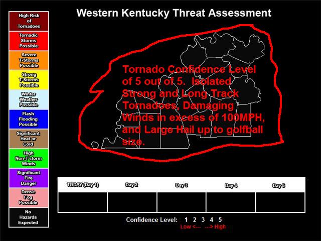
Tornado Watch is coming
http://www.spc.noaa.gov/products/md/md0370.html
The setup for cells, some could produce destrutive winds, large hail, and tornadoes that could be strong across Western Kentucky late this morning into the afternoon stay tuned for more updates.
The setup for cells, some could produce destrutive winds, large hail, and tornadoes that could be strong across Western Kentucky late this morning into the afternoon stay tuned for more updates.
April 24th storms

Moderate Risk of Severe Weather is in effect from Paducah to Livermore KY south. North of the Line a slight risk is in effect. Still watch out for the possibility of line segments and a squall line. Discrete Supercells cannot be ruled out. Storms can produce damaging winds, large hail, and tornadoes.
Friday, April 23, 2010

Tornado Number 83 until 3 am for these counties
KYC007-033-035-039-047-055-075-083-105-107-139-143-145-157-177-
    219-221-240800-
    /O.NEW.KWNS.TO.A.0083.100423T2350Z-100424T0800Z/

    KY
    .    KENTUCKY COUNTIES INCLUDED ARE

    BALLARD              CALDWELL            CALLOWAY
    CARLISLE             CHRISTIAN           CRITTENDEN
    FULTON               GRAVES              HICKMAN
    HOPKINS              LIVINGSTON          LYON
    MARSHALL             MCCRACKEN           MUHLENBERG
    TODD                 TRIGG
Update
A moderate Risk for Severe Weather is now in effect for all of Western KY, and Middle TN. In a complex situation a cluster of Long Track Supercells, and a MCS will move from Arklatex region to the Arklamiss region. Out ahead of it including West KY and West and Mid TN more storms could form that could produce large hail, damaging winds, and tornadoes. The time-frame should be anywhere from 10AM to 4 PM for West KY, and from 11:30am-7:30PM for Middle TN. towards the end of the time-frame a serial derecho may form.
The danger is if any storm tomorrow can produce a tornado, it can produce a long track tornado. With storm motions of 55 to 75MPH from SW to NE expected there will not be a lot of time to take cover, so if a Tornado Warning is issued take cover immediately.
A conference call is in the works right now, with more details.
http://www.crh.noaa.gov/pah/?n=briefs
Link to Conference Call.
Instability will be an issue. Shear, and Moisture return will be sufficient. Some of the Shear measurements are Four Times more than necessary for storm rotation. Instability with CAPE values only being in the 500-1000 range may limit the storms along with LI of only about -2 which isn't that great. Wind Shear, and Moisture Return will allow for storms to develop, and become severe whether it is just another event, or a potentially historic tornado outbreak will decide on if we can get any breaks in clouds, any more instability, where any MCS systems are at.
The danger is if any storm tomorrow can produce a tornado, it can produce a long track tornado. With storm motions of 55 to 75MPH from SW to NE expected there will not be a lot of time to take cover, so if a Tornado Warning is issued take cover immediately.
A conference call is in the works right now, with more details.
http://www.crh.noaa.gov/pah/?n=briefs
Link to Conference Call.
Instability will be an issue. Shear, and Moisture return will be sufficient. Some of the Shear measurements are Four Times more than necessary for storm rotation. Instability with CAPE values only being in the 500-1000 range may limit the storms along with LI of only about -2 which isn't that great. Wind Shear, and Moisture Return will allow for storms to develop, and become severe whether it is just another event, or a potentially historic tornado outbreak will decide on if we can get any breaks in clouds, any more instability, where any MCS systems are at.

Thursday, April 22, 2010
Complex storm here

A powerful system is currently on the move across the Plains. This system has produced tornadoes already in Colorado, Kansas, and the Oklahoma and Texas Panhandle Region. This storm is expected to drift on to the Northeast in which the threat of severe storms and tornadoes will go along with it.
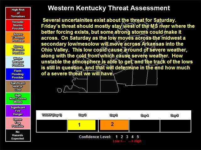
Western Kentucky and surrounding areas will also get to deal with this storm. For Western Kentucky the stage is setting for a long lived event that could start in after midnight tomorrow night, and go on into the afternoon and early evening hours of Saturday. This means that up to 18 hours of severe weather and heavy rain is possible.
The first round will be later on Friday mostly after might, but an isolated strong to severe storm cannot be ruled out in the late afternoon and early evening hours either, as the forcing and dynamics start to edge into the region. The threat for the most part here will be Large Hail, and maybe a Severe Wind Gust, although tornadoes cannot be totally ruled out the greatest threat on Friday Night will exist to our West.
The complex situation occurs on Saturday. Another low is expected to take over, as the low in IL occludes. This low is expected to move across East Arkansas into Far West KY and into Central Indiana. Along with this strengthening low the forcing, and shear(the change in wind direction or speed with height) will very strong. If sufficient instability can occur? Than a severe weather event is likely, maybe even a Severe Weather Outbreak. If instability struggles to build, and a big moisture sucking Deep South MCS is present, and lingers throughout the afternoon, than the threat will probably be limited to an isolated or scattered wind/hail event, with a brief spin-up possible. Locally heavy rain could also be possible with flooding issues in the heavier storms, along with strong Non-Thunderstorm Winds with gusts up to 45-50MPH.
Stay tuned to further details on this event.
Wednesday, April 21, 2010

Back for an event part 1
Back after a 2 week absence of working on college things. We will be tracking now an entertaining system for the weekend.
After a boring start to the year, or the decade we have the potential for action. The next post will go in a little more detail.
After a boring start to the year, or the decade we have the potential for action. The next post will go in a little more detail.
Wednesday, April 7, 2010
Hopkins County T-storm Warning
Severe Thunderstorm Warning for Hopkins County in Kentucky. Till 8:45PM A bow echo is shown on radar so damaging winds of 60 to 70MPH could be poss...ible in Earlington, Madisonville, Mortons Gap KY area.
Tornado Watch 61 extended due to precaution
With that due to the precaution of any spinup Tornado Watch extends for The Lakes area up towards Madisonville and the Henderson area.
Line in West KY
It appears that although a brief wind/spinup/threat cannot be ruled out. With the loss of sunlight, and the instability decreasing as you go further east that severe threat will lower the further east you go. That does not mean warnings cannot be issued, and if any warning goes in effect you should heed it.
Tornado Watch number 61
http://www.spc.noaa.gov/products/watch/ww0061.htmlTornado Watch has been issued for parts of Western Kentucky mostly the northern Purchase, and part of the Western Coal Fields, and Far NW Pennyroyal area. More details after 3.
As I got to go back to class for a short lecture.
As I got to go back to class for a short lecture.
April 7th overview

Strong to Severe storms are possible in the afternoon and evening hours. Damaging Winds, Isolated Large Hail, Locally Heavy Rain, and Vivid Lightning are possible threats in the strongest storms.
Tuesday, April 6, 2010


Sunday, April 4, 2010

Saturday, April 3, 2010
Same post about the Super Outbreak just another year has past.
The Super Outbreak of April 3rd 1974. Deadly tornadoes IN, OH, KY,TN,AL devastated. 6 F5's and 24 F4's
West KY didn't get hit by a tornado but got hit by several storms producing baseball sized hail. Central KY and Mid TN was a different story.
In Middle TN 38 deaths occurred more than the Super Tuesday Outbreak. As a strong 986MB low moved across North IL to Central MI area bringing a strong cold front until the area. A very strong pacific jet along with a gulf jet collided ahead of the strong cold front. Strong Instability, Off the charts shear, lift, and great moisture return were all present. Several F3 and F4 tornadoes hit the area of Mid TN
One of the most damaging tornadoes in Mid TN was Putnam County. A tornado formed around Macedonia. This tornado rapidly booked to the northeast across SE outskirts of Cookeville. It went though the Upper Cumberland Regional Airport before entering the Poplar Grove area. There it crossed I-40 between Rocky Springs and Sand Springs before crossing the north outskirts of Monterey and moving ton Fentress County along the Green Pond and Hanging Limb areas.
One hit in Fentress County NE of a town called Obey City to just Se of Jamestown. In a subdivision to the south of Jamestown 50 homes were completely demolished. 7 deaths occurred
In Pickett County the Moodyville area suffered 5 deaths with houses demolished.
In Livingston TN 2 tornadoes struck the town of Livingston. One of them was an F1 the most devastating one was an F3 that destroyed a good deal of the buildings in the town and killed 3 people.
The most devastating one was an upper end F4 originally an F5 but changed to an upper end F4 in Lincoln and Franklin counties in TN. another F4 hit the same area after the first F4 struck the area causing homes to be destroyed foundation and all. it started around Vantown along AL border. one F4 went into Flintville the other to a mile to the east so after. the town of Lexie TN got hit by two F4's back to back and was devastated. Than one F4 went more NE into the Arnold AFB. into Coffee county. the other smacked into Estill Springs and finally came to rest in Woods Reservoir.
The first one that came from Alabama is the most devastating one and the deadliest Mid TN tornado. Originally it was rated a F5 but upon investigation was changed to a upper end of F4.
West KY didn't get hit by a tornado but got hit by several storms producing baseball sized hail. Central KY and Mid TN was a different story.
In Middle TN 38 deaths occurred more than the Super Tuesday Outbreak. As a strong 986MB low moved across North IL to Central MI area bringing a strong cold front until the area. A very strong pacific jet along with a gulf jet collided ahead of the strong cold front. Strong Instability, Off the charts shear, lift, and great moisture return were all present. Several F3 and F4 tornadoes hit the area of Mid TN
One of the most damaging tornadoes in Mid TN was Putnam County. A tornado formed around Macedonia. This tornado rapidly booked to the northeast across SE outskirts of Cookeville. It went though the Upper Cumberland Regional Airport before entering the Poplar Grove area. There it crossed I-40 between Rocky Springs and Sand Springs before crossing the north outskirts of Monterey and moving ton Fentress County along the Green Pond and Hanging Limb areas.
One hit in Fentress County NE of a town called Obey City to just Se of Jamestown. In a subdivision to the south of Jamestown 50 homes were completely demolished. 7 deaths occurred
In Pickett County the Moodyville area suffered 5 deaths with houses demolished.
In Livingston TN 2 tornadoes struck the town of Livingston. One of them was an F1 the most devastating one was an F3 that destroyed a good deal of the buildings in the town and killed 3 people.
The most devastating one was an upper end F4 originally an F5 but changed to an upper end F4 in Lincoln and Franklin counties in TN. another F4 hit the same area after the first F4 struck the area causing homes to be destroyed foundation and all. it started around Vantown along AL border. one F4 went into Flintville the other to a mile to the east so after. the town of Lexie TN got hit by two F4's back to back and was devastated. Than one F4 went more NE into the Arnold AFB. into Coffee county. the other smacked into Estill Springs and finally came to rest in Woods Reservoir.
The first one that came from Alabama is the most devastating one and the deadliest Mid TN tornado. Originally it was rated a F5 but upon investigation was changed to a upper end of F4.
Friday, April 2, 2010
April 2nd Tornado Outbreak: 4 years ago
 The following image is of a tornado just to the north of Hopkinsville Kentucky on the night of April 2nd 2006.
Today is the third year anniversary of the April 2nd 2006 Tornado Outbreak.
This outbreak features a handful of tornadoes in West KY and West Mid TN, and also a serial derecho across Northwest Kentucky.
A F-3 crossed Christian and Todd counties and impacted the north part of Hopkinsville, and the communities of Allegre and Sinking Fort as well. Around 30 injuries and 38 million dollars of damage occurred in those two counties luckily no fatalities occurred.
A F-1 caused damage across the Camden TN area of Benton County TN.
A brief F-0 tornado touched down in Gage KY on the Ballard/McCracken county line.
Widespread wind damage occurred across Henderson and Owensboro due to a Serial Derecho.
Sadly there were fatalities in West TN, Thankfully Mid TN and West KY got spared that aspect of the event, still hold prayers for some of the victims in Dyer, and Gibson Counties in West TN.
Links for more details.
http://www.crh.noaa.gov/pah/?n=apr0206event
http://www.spc.noaa.gov/climo/reports/060402_rpts.html
http://www.srh.noaa.gov/ohx/?n=stormsurvey04022006
Tornado Warnings for the Two main Supercells
http://mesonet.agron.iastate.edu/vtec/#2006-O-NEW-KOHX-TO-W-0021
http://mesonet.agron.iastate.edu/vtec/#2006-O-NEW-KPAH-TO-W-0053
http://mesonet.agron.iastate.edu/vtec/#2006-O-NEW-KPAH-TO-W-0054
Red Flag Warning for east of the lakes
URGENT - FIRE WEATHER MESSAGE
NATIONAL WEATHER SERVICE PADUCAH KY
424 AM CDT FRI APR 2 2010

.ANOTHER DAY OF GUSTY SOUTHWEST WINDS AND LOW AFTERNOON RELATIVE
HUMIDITY IS EXPECTED TODAY AS HIGH PRESSURE REMAINS ENTRENCHED
OVER THE EASTERN SEABOARD.

INZ081-082-085>088-KYZ010>022-021730-
/O.NEW.KPAH.FW.W.0001.100402T1700Z-100402T2300Z/
GIBSON-PIKE-POSEY-VANDERBURGH-WARRICK-SPENCER-CRITTENDEN-LYON-
TRIGG-CALDWELL-UNION KY-WEBSTER-HOPKINS-CHRISTIAN-HENDERSON-
DAVIESS-MCLEAN-MUHLENBERG-TODD-
424 AM CDT FRI APR 2 2010

...RED FLAG WARNING IN EFFECT FROM NOON TODAY TO 6 PM CDT THIS
EVENING...

THE NATIONAL WEATHER SERVICE IN PADUCAH HAS ISSUED A RED FLAG
WARNING...WHICH IS IN EFFECT FROM NOON TODAY TO 6 PM CDT THIS
EVENING FOR SOUTHWEST INDIANA AND PARTS OF WESTERN KENTUCKY. THE
RED FLAG WARNING AREA IS EAST OF KENTUCKY LAKE...AND IT INCLUDES
THE LAND BETWEEN THE LAKES NATIONAL RECREATION AREA.

BURNING CONDITIONS WILL BE VERY SIMILAR TO THURSDAY...EXCEPT THAT
WINDS ARE EXPECTED TO BE A LITTLE STRONGER TODAY IN THE WARNING
AREA. MINIMUM RELATIVE HUMIDITY THIS AFTERNOON WILL BE NEAR 25
PERCENT. SOUTH TO SOUTHWEST WINDS WILL AVERAGE ABOUT 15 MPH IN
OPEN AREAS...WITH GUSTS AROUND 25 MPH THIS AFTERNOON. FUEL
MOISTURE WILL REMAIN BELOW THE CRITERIA FOR A RED FLAG WARNING.

PRECAUTIONARY/PREPAREDNESS ACTIONS...

A RED FLAG WARNING MEANS THAT CRITICAL FIRE WEATHER CONDITIONS
ARE EITHER OCCURRING NOW...OR WILL SHORTLY. A COMBINATION OF
STRONG WINDS...LOW RELATIVE HUMIDITY...AND DRY FUELS WILL CREATE VERY
HIGH FIRE GROWTH POTENTIAL.

&&

$$

YORK
Subscribe to:
Posts (Atom)


 Posts
Posts


