Highlighted Community: Great Salt Lake/Bonneville Salt Flats
I did not get to directly visit the Great Salt Lake (barely saw it from a mountaintop video) or the adjacent salt flats, but since this area is so intriguing I feel like I could not do the Northern Utah highlighted series without a blog episode about it. Credit was given in the photos since I was unable to get photos personally from these areas.
Location:
Great Salt Lake is a large lake that is located just west of Salt Lake City. One interesting thing to note is that there is not direct access from the lake from Salt Lake City. The closet would be going to Antelope Island State Park which is just west of Syracuse, Utah in Davis County which is about a 30-35 minute drive from Salt Lake City. The Bonneville Salt Flats are located just west of Great Salt Lake and for the most part are located in Tooele County. They stretch over 30,000 acres and cover much of Tooele County and adjacent parts of other counties and even a small part of Nevada near West Wendover.

Weather/Climate:
The Bonneville Salt Flats feature an Arid Climate which is classified as a BWk (Cold Desert) under the Koppen Climate Classification. This climate features hot summers like you would typically associate with a desert with highs sometimes reaching into the triple digits, but winters are on the colder side and occasionally feature snow. Areas closer to the Great Salt Lake tend to get more snow and can even receive heavy lake effect snow.

How did Great Salt Lake and the Bonneville Salt Flats Form?:
Great Salt Lake and the Bonneville Salt Flats are in a part of the United States known as the Great Basin. A basin is a bowl-like landform that is surrounded on all sides by higher elevations. The Wasatch Mountains to the east, the Columbia Plateau to the north, the Colorado Plateau to the south,, and the Sierra Nevada mountain range to the west surround the lower elevation Great Basin that covers much of Nevada, southeastern Oregon, and the western half of Utah.
During the Ice Age this area was part of a large lake called Lake Bonneville as this area became a drainage area due to its bowl shape (think of a giant bath tub) along with increased precipitation and decreased evaporation across the board. Lake Bonneville covered modern day Salt Lake City, Provo, Wendover, and even adjacent parts of Nevada and Idaho (Figure 3).

As the climate turned warmer at the end of the Ice Age the evaporation rate increased. Higher Temperatures = Higher Evaporation Rates. Since Lake Bonneville was in a basin there was no outlet for the water so as temperatures began to warm the lakewater started to evaporate or gradually seep into the ground. When the lake began to evaporate it left behind other particles that were not water such as salt. This continued till all that was left from Lake Bonneville was Great Salt Lake and other smaller lakes such as Utah Lake, which is west of Provo. Since these lakes lack sufficient inflow from other sources freshwater is unable to get to them combined with evaporation leaving behind products such as salt allows for the salinity of these lakes to be greater than even the ocean. Also the shallow groundwater allows for any salt to be pushed to the surface. The exception to this is during periods of solid rain that can dissolve the salt at the surface and create ponds.
Great Salt Lake Today:
The Great Salt Lake is currently one of the largest saline lakes in the Western Hemisphere. It covers portions of several counties just west of Salt Lake City and Ogden, Utah. Due to the high saline content which is over seven times as much as the ocean, humans can float in the Great Salt Lake. The salinity also impacts the life that can live there. Some parts only algae can survive and in those parts of the Great Salt Lake you can see the lake turn a pink color due to the specialized algae that live there. Brine shrimp and brine flies can also live there as well.
Currently due to the arid to semiarid climate and increasing temperatures there is the risk of the Great Salt Lake disappearing which will threaten the local ecosystem. The Great Salt Lake is too saline to use as drinking water.


Bonneville Salt Flats Today:
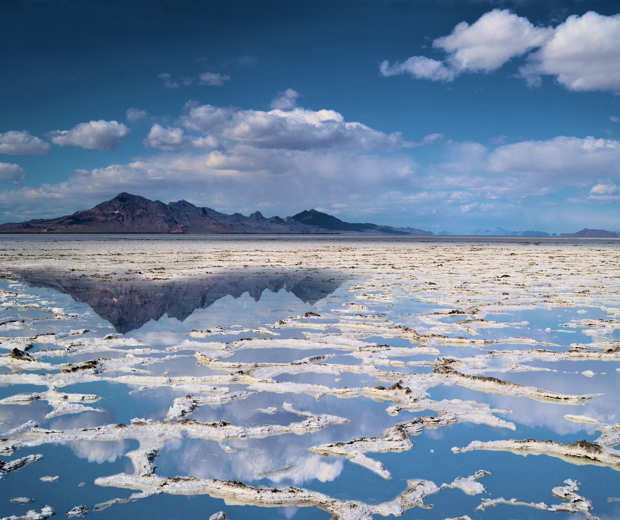
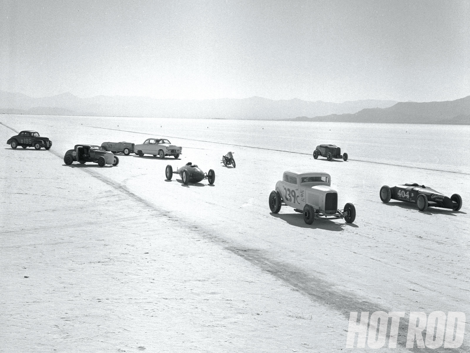
The Bonneville Salt Flats is an example of a vast and flat desert. This makes an ideal situation for racing because you have a vast and flat landscape. This also makes a perfect landscape for pictures as well. During rainstorms ponding of water can occur and when this happens the ponding can act as a mirror and reflect the surrounding landscape. This area is starting to shrink due to salt mining and local climate factors.
WOW! Comparison to World of Warcraft (Possible Influence):
In the World of Warcraft, before the events of Cataclysm the area of Thousand Needles was very Utah-like in its landscape. Which included mesas, red rocks, and mining operations. The most Utah thing in the world of Thousand Needles is a zone known as Shimmering Flats. Shimmering Flats is a giant salt flat that leads to a zone that is not too dissimilar in appearance to Southern Nevada or Arizona. Similar to the Bonneville Salt Flats there is a racing facility. Also there are some abandoned boats that suggest that just like the Bonneville Salt Flats the area was once a lake. In the Cataclysm area the area becomes a lake again, which is not expected to be the fate of Northwest Utah. The following pictures are of the World of Warcraft world posted by various online sources compared to pictures from other photographers of the Bonneville Salt Flats. Could it be possible that this area influenced the developers of the World of Warcraft? That will be up for you to decide.


Conclusion:
The Great Salt Lake and the Salt Flats are both definitly interesting places to visit in Utah. When visiting the Great Salt Lake the recommed place is at Antelope Island State Park which is north of Salt Lake City in Syracuse, Utah. You cannot access the lake directly from the city because it is surrounded by wetlands.
The salt flats are accessed from Interstate 80. It does take several hours to reach the scenic stop off I-80 (Exit 10) or the Bonneville Salt Flat Speedway which is Exit 4 (meaning 4 miles from the Nevada/Utah state line). That is why I wasn’t able to personally directly view the area because it takes 1 hour and 45 minutes to get there from Salt Lake City just one-way and assuming normal traffic. The salt flats do make a good backdrop for photographs especially if you can make it over there after a rain storm to have that mirror effect. All in all they are both good places to visit in Northern Utah.
Coming up in the next week or so will be Highlighted Salt Lake City, Utah to close out the Northern Utah Highlighted Community Series. As I start my teaching job, posts will probably be sparse but I will do my best to have at least a few per month.


No comments:
Post a Comment