Thursday, January 24, 2013
Some icing issues
In Western KY despite the limited precipitation travel problems could still develop tonight and tomorrow. In Northwestern KY and the Purchase we are probably looking at a dusting to less than half inch of snow and sleet. Along the KY/TN border there may be a little bit more precipitation, but also more in the form of freezing rain and sleet. Ice accumulation of a few hundredths of an inch to a tenth of an inch are possible along the KY/TN border. Remember that even though precipitation values will be light, due to cold ground surfaces there still may be travel issues, and any wintry precip will form slick spots especially on bridges and overpasses.

Tuesday, January 15, 2013
Update
There are reports of snow/sleet mix with some wrecks in the Paducah/Benton KY area.
Ice is starting to spread across the KY/TN border into Kentucky. Main and well traveled roads during this event should be okay for the most part because the temps are close to freezing. It will be the bridges, the overpasses, on and off ramps, and secondary roads that are on locally geological high places that will be the major problem spots in the area.
Ice is starting to spread across the KY/TN border into Kentucky. Main and well traveled roads during this event should be okay for the most part because the temps are close to freezing. It will be the bridges, the overpasses, on and off ramps, and secondary roads that are on locally geological high places that will be the major problem spots in the area.
Winter Storm Warning for Todd County
Winter Storm Warning for Todd County. 1/4 inch
of ice possible in Southern Todd County. This 1/4 zone could extend
from Oak Grove to Elkton to even Bowling Green KY.
Wintry Mix Blues
Areas in southwestern KY and from in Middle TN
west of an Lafayette to Lynchburg TN line(not including the Ice Storm
Warning) are under a Winter WX Advisory. These areas can see freezing
drizzle or freezing rain changing to rain overnight. Ice accumulations
will range from a few hundredths of an inch to .24 inches. This amount
of ice is still enough to coat elevated surfaces and make elevated roads,
overpasses, and bridges difficult to travel on. Cities included are
Murray, Fulton, Madisonville, Greenville, Hopkinsville, Bowling Green,
Clarksville TN, Ashland City TN, Gallatin TN, Nashville TN,
Fairview/Franklin/Brentwood TN, Columbia TN, Lawrenceburg TN, Lebanon
TN, and Murfressboro TN and surrounding areas of those cities.
Saturday, January 12, 2013
Update and PAH link
Remember to use this link for updated warnings and flooding reports. http://www.crh.noaa.gov/pah/
If you see water over a roadway and you cannot see the roadway underneath do not cross it.
If you see water over a roadway and you cannot see the roadway underneath do not cross it.
Paducah KY Tornado Warning
http://forecast.weather.gov/
Tornado Warning for McCracken and far SW Livingston County
Tornado Warning for McCracken and far SW Livingston County
Thursday, January 10, 2013
Weekend storm
The threat for localized heavy rain and maybe is still there, but due to the rain being spread out over a few days I think there could be some localized flooding in areas where heavier bands track, but overall I'm not expected a widespread high-inpact flooding event. There may be an isolated strong to severe storm tonight and during the weekend system, but don't expect widespread severe weather. We do need to watch the backend of this system from Sunday Night-Tuesday there may be some freezing rain mixing in at times.
Sunday, December 30, 2012
Winter WX Advisory for NW KY
http://forecast.weather.gov/
Winter WX Advisory for Union,Henderson, and Daviess Counties for the New Years event. Much of Western KY and all of TN will remain all or mostly air rain, but these counties may get some minor ice accumulation before the changeover to rain.
Winter WX Advisory for Union,Henderson, and Daviess Counties for the New Years event. Much of Western KY and all of TN will remain all or mostly air rain, but these counties may get some minor ice accumulation before the changeover to rain.
Friday, December 28, 2012
Heavy Snow
A very heavy snow band is moving along the Ohio River. Ballard, McCracken, Livingston, north Marshall, Crittenden Counties appear to be under the heaviest returns. Which could feature 1 inch a hour snowfall and maybe some lightning strikes.
Call map for tonight's winter event.

Update
Some models are showing the snow band tonight to be wider. Depending on how the temperatures go and how quick the changeover there is a chance all of Western KY and maybe even portions of Northwestern Middle TN could see measurable snow.
Winter Weather Advisory
A Winter Weather Advisory is in effect for areas along and north of the Western KY Parkway. 1 to 3 inches of snow is expected with some sleet mix. Better chances closer to the Ohio River.
Wednesday, December 26, 2012
Widespread Blizzard in Northwest and far West parts of KY
Most everyone is to snow. Remember if you are traveling from say Henderson KY to Benton KY to Mayfield KY westward don't. There is widespread blowing and drifting of the snow and blizzard conditions ongoing.
Tuesday, December 25, 2012
Links
http://www.radioreference.com/apps/audio/
^^Scanner Links^^
http://weatherobservatory.com/radar_grearth2.htm
^^ Radar Link^^
http://www.crh.noaa.gov/pah/
^^ NWS Paducah site^^
^^Scanner Links^^
http://weatherobservatory.com/radar_grearth2.htm
^^ Radar Link^^
http://www.crh.noaa.gov/pah/
^^ NWS Paducah site^^
The last update for the night
The event still looks to play out not like my morning thoughts, but more of my afternoon thoughts. Smithland to Mayfield to Fulton KY westward will be the big winners. The eastern edge of that band may reach to near or just west of LBL. Scattered snow showers towards daybreak will supply the snow for the areas east of LBL. Thinking 1-3 east of LBL and North Middle TN. It is a wait and see and surprises may occur. Even with only 1-3 inches of snow blowing and drifting of snow will be a major issue with 40-45MPH wind gusts. Travel is not recommended from later tonight into tomorrow. The event will start in far West KY in 2 hours and spread eastward towards daybreak.
Update
http://weatherobservatory.com/radar_grearth2.htm
A good radar for this event. Just because the snow amounts have been reduced(for areas east of LBL) there still will be issues with blowing and drifting of the snow that falls.
A good radar for this event. Just because the snow amounts have been reduced(for areas east of LBL) there still will be issues with blowing and drifting of the snow that falls.
I forgot the dry slot

HPC maps
The following are some links from the HPC which show the chances of the Winter Storm.
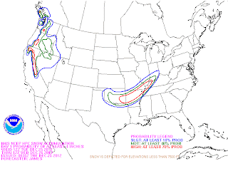
 The first map is the chance of receiving 4 or more inches of snow and the second one is the chance of receiving 8 or more inches of snow.


It is about to happen
Blizzard Warning for all of Western KY(Winter Storm Watch for Christian and Todd). We are looking at a plains style blizzard. As of now looking at 3 to 9 inches of snow across Western KY with a sharp cutoff somewhere around Eastern Christian/Todd/Logan Counties between the heavier snows and the rain/light snow mix. Areas in the snow band will experience 35-45MPH wind gusts, heavy snow fall rates, whiteout conditions, potential thunder and lightning, and a chance at power outages, drifts may reach several feet in areas that are prone to drifting.
Timing of the worst impacts will be from 10pm-8am.
Timing of the worst impacts will be from 10pm-8am.
Monday, December 24, 2012

Blizzard Watch
A Blizzard Watch has been put into effect for parts of Western KY. This is major guys, but still a very close call. The models have slid SE enough to where Blizzard Conditions are possible from a Henderson to Smithland to Paducah to Fulton line westward. Other areas of Western KY may cash in depending on model track.
Dense Fog Advisory for Western KY
http://forecast.weather.gov/showsigwx.php?warnzone=KYZ017&warncounty=KYC047&firewxzone=KYZ017&local_place1=&product1=Dense+Fog+Advisory
Winter Storm Watch
Breaking News a Winter Storm Watch is in effect for Fulton, Hickman, Carlislie, Ballard, McCracken, Livingston, Crittenden, Union, Henderson, and Webster Counties for the Christmas Night-26th storm
Thursday, December 20, 2012
High Wind threat
Wind gusts of 45-57MPH likely across Western Kentucky and 40-49 across Middle TN today. Travel will be hazardous with high profile vehicles, and there is potential for damage to Christmas Decorations and even some minor tree-powerline damage.
Sunday, December 9, 2012
Tornado Watch 677
TORNADO WATCH 677 IS IN EFFECT UNTIL 900 PM CST FOR THE
FOLLOWING LOCATIONS
KENTUCKY COUNTIES INCLUDED ARE
BALLARD CALLOWAY CARLISLE
FULTON GRAVES HICKMAN
LIVINGSTON MARSHALL MCCRACKEN
FOLLOWING LOCATIONS
KENTUCKY COUNTIES INCLUDED ARE
BALLARD CALLOWAY CARLISLE
FULTON GRAVES HICKMAN
LIVINGSTON MARSHALL MCCRACKEN
Subscribe to:
Posts (Atom)


 Posts
Posts


