Friday, December 28, 2012
Winter Weather Advisory
A Winter Weather Advisory is in effect for areas along and north of the Western KY Parkway. 1 to 3 inches of snow is expected with some sleet mix. Better chances closer to the Ohio River.

Wednesday, December 26, 2012
Widespread Blizzard in Northwest and far West parts of KY
Most everyone is to snow. Remember if you are traveling from say Henderson KY to Benton KY to Mayfield KY westward don't. There is widespread blowing and drifting of the snow and blizzard conditions ongoing.
Tuesday, December 25, 2012
Links
http://www.radioreference.com/apps/audio/
^^Scanner Links^^
http://weatherobservatory.com/radar_grearth2.htm
^^ Radar Link^^
http://www.crh.noaa.gov/pah/
^^ NWS Paducah site^^
^^Scanner Links^^
http://weatherobservatory.com/radar_grearth2.htm
^^ Radar Link^^
http://www.crh.noaa.gov/pah/
^^ NWS Paducah site^^
The last update for the night
The event still looks to play out not like my morning thoughts, but more of my afternoon thoughts. Smithland to Mayfield to Fulton KY westward will be the big winners. The eastern edge of that band may reach to near or just west of LBL. Scattered snow showers towards daybreak will supply the snow for the areas east of LBL. Thinking 1-3 east of LBL and North Middle TN. It is a wait and see and surprises may occur. Even with only 1-3 inches of snow blowing and drifting of snow will be a major issue with 40-45MPH wind gusts. Travel is not recommended from later tonight into tomorrow. The event will start in far West KY in 2 hours and spread eastward towards daybreak.
Update
http://weatherobservatory.com/radar_grearth2.htm
A good radar for this event. Just because the snow amounts have been reduced(for areas east of LBL) there still will be issues with blowing and drifting of the snow that falls.
A good radar for this event. Just because the snow amounts have been reduced(for areas east of LBL) there still will be issues with blowing and drifting of the snow that falls.
I forgot the dry slot

HPC maps
The following are some links from the HPC which show the chances of the Winter Storm.
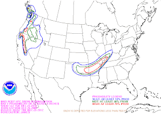
 The first map is the chance of receiving 4 or more inches of snow and the second one is the chance of receiving 8 or more inches of snow.


It is about to happen
Blizzard Warning for all of Western KY(Winter Storm Watch for Christian and Todd). We are looking at a plains style blizzard. As of now looking at 3 to 9 inches of snow across Western KY with a sharp cutoff somewhere around Eastern Christian/Todd/Logan Counties between the heavier snows and the rain/light snow mix. Areas in the snow band will experience 35-45MPH wind gusts, heavy snow fall rates, whiteout conditions, potential thunder and lightning, and a chance at power outages, drifts may reach several feet in areas that are prone to drifting.
Timing of the worst impacts will be from 10pm-8am.
Timing of the worst impacts will be from 10pm-8am.
Monday, December 24, 2012

Blizzard Watch
A Blizzard Watch has been put into effect for parts of Western KY. This is major guys, but still a very close call. The models have slid SE enough to where Blizzard Conditions are possible from a Henderson to Smithland to Paducah to Fulton line westward. Other areas of Western KY may cash in depending on model track.
Dense Fog Advisory for Western KY
http://forecast.weather.gov/showsigwx.php?warnzone=KYZ017&warncounty=KYC047&firewxzone=KYZ017&local_place1=&product1=Dense+Fog+Advisory
Winter Storm Watch
Breaking News a Winter Storm Watch is in effect for Fulton, Hickman, Carlislie, Ballard, McCracken, Livingston, Crittenden, Union, Henderson, and Webster Counties for the Christmas Night-26th storm
Thursday, December 20, 2012
High Wind threat
Wind gusts of 45-57MPH likely across Western Kentucky and 40-49 across Middle TN today. Travel will be hazardous with high profile vehicles, and there is potential for damage to Christmas Decorations and even some minor tree-powerline damage.
Sunday, December 9, 2012
Tornado Watch 677
TORNADO WATCH 677 IS IN EFFECT UNTIL 900 PM CST FOR THE
FOLLOWING LOCATIONS
KENTUCKY COUNTIES INCLUDED ARE
BALLARD CALLOWAY CARLISLE
FULTON GRAVES HICKMAN
LIVINGSTON MARSHALL MCCRACKEN
FOLLOWING LOCATIONS
KENTUCKY COUNTIES INCLUDED ARE
BALLARD CALLOWAY CARLISLE
FULTON GRAVES HICKMAN
LIVINGSTON MARSHALL MCCRACKEN
Wednesday, October 17, 2012
T-Storm Watch
T-Storm 669 till 2am for the rest of Western KY east of US 45. Areas along and west of US 45 are under a Tornado Watch.
Tuesday, October 16, 2012
Slight Risk of severe tomorrow.
There is a slight risk of severe weather across all of West KY and portions of far Northwest Middle Tennessee tomorrow evening and tomorrow night. This exists from a Parsons TN line to a Guthrie KY line westward. The strongest storms may contain damaging winds. In a highly sheared environment a brief funnel/tornado spin-up cannot be totally ruled out.
Sunday, October 14, 2012
Mayfield KY survey
http://forecast.weather.gov/
The Mayfield KY damage from this morning was caused by a tornado.
The Mayfield KY damage from this morning was caused by a tornado.
Wednesday, October 10, 2012
Sunday, September 23, 2012
Frost Possible
http://forecast.weather.gov/showsigwx.php?warnzone=KYZ017&warncounty=KYC047&firewxzone=KYZ017&local_place1&product1=Frost+Advisory
Frost Advisory just like with last night lows of 34-41 causing patchy frost in rural areas in West KY and NW Middle TN.
Frost Advisory just like with last night lows of 34-41 causing patchy frost in rural areas in West KY and NW Middle TN.
Monday, September 17, 2012
Im ready
Highs in the upper 60's tomorrow and lows tomorrow night into Wednesday morning will bottom out to the 38-44 range. I'm ready.
Friday, September 7, 2012
Severe Thunderstorm Watch
A cluster/line segment of storms is about to cross the Miss. River. Severe storms are possible with damaging winds of 58-70MPH being the main threat as the storms move through the area. Impacts will be felt along the Ohio River and MS River at around 9ish, and clear Western KY and NW Middle TN at around midnight, and press on towards the Nashville TN area after midnight. T-Storm Watch for West KY till midnight.
Saturday, September 1, 2012
Overview
An interesting first day of fall severe weather season. Reports of a brief tornado in far West McCracken county. Thankfully the damage in Ballard/McCracken counties is only tree/powerline type, and no injuries of any sort. Locally Heavy rain tonight. May be a strong storm in West Middle TN, but think the tornado threat is over for the night.
Tornado on the ground
Tornado report on the ground near Woodville KY moving towards the nw part of Paducah before going into Massac County IL. Take cover now in that area don't wait.
Severe update
Funnel Cloud in far north Ballard County 6 moving towards Bandana and Monkey's Eyebrow
region. Could produce a tornado at anytime.
Tornado Warning NW McCracken and Ballard County.
region. Could produce a tornado at anytime.
Tornado Warning NW McCracken and Ballard County.
Subscribe to:
Posts (Atom)


 Posts
Posts


