Sunday, November 30, 2008

dusting to an inch

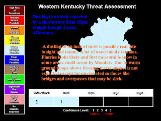
Dusting to an inch of snow expected from 10pm tonight though Tomm. Afternoon . Warm ground temps should melt some of the accumulation esp on roads so travel issues wont be a problem.

Any accumulation should be expected to be on grassy surfaces if at all. School cancellations and delays seem unlikely for most of West Ky because of warm ground temps and lack of snow getting on the roads.

Saturday, November 29, 2008

first call maps


Just click to enlarge. Beware because of terrain take forecasts in TN from the Cumberland Plateau eastward with a grain of salt.

Went conservative because of the model difficulty.

Wednesday, November 26, 2008

attack on India

my prayers are for the victims from the terrorist attack in India

weather update

Although there is a lot of model disagreement and moisture and temps may be a problem. There might be enough energy for pot. for light accumulations from N MS/N AL across TN and KY into IN for Nov 30th/Dec 1st but will be very conservative at this point.

Something to watch after Turkey Day.

Thanksgiving will be dry with average to slightly above temps. In the 54 to 59 range expected even the brawl on isle 9 Friday sound be dry. In West KY

Monday, November 24, 2008

Calloway county tornado 7 years ago

On Nov 24th 2001 a rotating storm struck Calloway county west of Murray. It hit a community of Harris Grove. It devastated several farmlands and leave a few people injured as it struck at around 6:30am. Luckily no deaths occurred in the strong F2 tornado.

http://www.crh.noaa.gov/pah/storm/harrisgr.php

It occurred in a very high shear and low cape setup.

Afterwords on Nov 26th a deadly tornado struck in eastern Henry County TN.

Heads up!!! Cold December?

Got a message from David Powell about confidence growing for cold.


For me I say that is growing from most everybody heck even conservative NOAA about a very nasty cold snap in the midst. This cold snap will set dangerous temperatures all the way down to the gulf and S Texas if worst case scenario occurs. Remember this is worst case scenario and why I am and a lot of people are very confident in this cold snap which could occur during most if not all of the month of December. With all cold air bottled up in Canada and Alaska and pot. for a western ridge to setup in western US along with a -nao cold air could be locked in the eastern 2/3rds of the country. Worst case or best case for cold lovers we deal with record cold across the month of December. That is just worst case if that doesn't happen we should still probably without a shadow of a doubt see some decent cold. Whether it would be glancing and somewhat intense cold shots of 2006-07 or Dec 1989 or 2000 all over again still is hard to tell. Better have plans of warming up next month because we look to at least deal with some shots of pretty chilly conditions at least. I agree with what David said. " Even though confidence is high there still is always some uncertainty, but as far as preparing for the cold I would start getting prepared better safe than sorry."

Some Serious and Sad News

May Hope be with Jere McCuiston and hope for a speedy recovery. I know the lord is with us though this tough times.
Following From David Powell

This just in...Some serious news to report....I have been informed that State Emergency Manager for Area 2, Jere McCuiston, is in St. Thomas Hospital in Nashville and is scheduled for open heart surgery tomorrow morning. Vickie Martin from the area 2 office, told me she visited with him yesterday and he is doing well. The cardiac surgeon told him that the main artery is 95% blocked and the stent that was put in 15 months ago is also blocked. All our prayers should be with him and we hope for a speedy recovery. I'll let you know more when I know more.
David Powell
Weather Coordinator
Christian County Emergency Management

nov 24

Sunday, November 23, 2008

Saturday, November 22, 2008

NWS Louisville Facts last day of Winter Awareness Week.

THIS HAS BEEN WINTER WEATHER PREPAREDNESS WEEK IN INDIANA AND KENTUCKY. THE
NATIONAL WEATHER SERVICE...WITH ITS PARTNERS IN STATE AND LOCAL
GOVERNMENT AND THE RED CROSS URGE YOU TO BE PREPARED FOR WINTER.

THOUGH WE DO NOT KNOW HOW BAD THIS WINTER WILL BE...WE DO
KNOW COLD AND SOME SNOW OR FREEZING RAIN EVENTS WILL CAUSE
PROBLEMS IN OUR DAILY LIVES. BEING PREPARED AND HAVING A PLAN
WILL HELP MINIMIZE THE IMPACT BY WEATHER.

REMEMBER NATIONAL WEATHER SERVICE OUTLOOKS AND WATCHES
GIVE YOU A HEADS UP ON STORM POTENTIAL DAYS IN ADVANCE.
WEATHER WARNINGS AND ADVISORIES MEANS WEATHER THAT IS LIKELY
TO CAUSE YOU PROBLEMS HAS ALREADY BEGUN OR WILL BEGIN SOON.

SOME WINTER WEATHER RELATED DEATHS RESULT FROM EXPOSURE TO
COLD SO DRESS APPROPRIATELY. MOST WINTER WEATHER RELATED
DEATHS ARE FROM AUTO ACCIDENTS ON SLIPPERY ROADS SO DRIVE
WITH MORE CAUTION WHEN ROADS ARE BAD. OTHER DEATHS RESULT
FROM FIRES DUE TO OVERLOADED ELECTRICAL CIRCUITS SO DO NOT
PLUG TOO MANY ITEMS INTO AN OUTLET. POORLY MAINTAINED
HEATING SYSTEMS ALSO LEAD TO DEATHS IN FIRES OR BY CARBON
MONOXIDE POISONING. HAVE YOUR FURNACE AND CHIMNEY CHECKED
BY PROFESSIONALS FOR PROPER OPERATION AND VENTING.

HAVE ADEQUATE SUPPLIES AVAILABLE AT HOME...AT WORK...ON THE
FARM...OR IN YOUR VEHICLE TO LAST FOR SEVERAL DAYS. HAVE
ALTERNATE SOURCES OF HEAT AND POWER AVAILABLE. HAVE MULTIPLE
SOURCES OF WEATHER INFORMATION AVAILABLE. ALWAYS CONSIDER
CHANGING PLANS WHEN THE WEATHER IS EXPECTED TO TURN BAD.

THE BEST WAY TO STAY SAFE DURING WINTER IS TO BE PREPARED. USE
COMMON SENSE AND CAUTION. LISTEN TO NOAA WEATHER RADIO OR
COMMERCIAL RADIO OR TELEVISION FOR THE LATEST INFORMATION.
TAKE ACTION WHEN THE NATIONAL WEATHER SERVICE ISSUES A
WATCH...WARNING OR ADVISORY

Friday, November 21, 2008

Cold Cold and Cold

One of the most dangerous aspects of Winter is the Extreme Cold. Even in the warmest of winters temps do go down to the teens with wind chills near zero at least briefly. The most dangerous aspect of winter is the Wind Chill.

Wind Chill is not the actual temperature, but what it feels like to your skin and skin of animals when the wind blows on a cold day. That is why a winter day with a temp of 40 feels so cold when there are 20 to 30mph gusts to the north. The wind removes heat from your body quicker. Also even in calm winds activities like riding in a car with the window down, ATV riding, snowboarding generate their own wind to the mix.

So riding on an ATV at 20mph on a calm wind day with a temp of 20 degrees (if it isnt a calm wind day add to the wind that is already there) cools the riders of the ATV to a 4 degree windchill.

In some intense cold snaps like the Feb 96 and Jan 94 one or even Dec 2004 after the storm can chill you if wind was blowing to wind chills below -40 degrees causing frostbite to exposed skin within 10 minutes. So even in West KY the frostbite and freezing you to death can actually happen. Severe frostbite and hypothermia can result in pain, loss of limbs, and pot. death and organ failure of kidneys and liver.

- In the intense cold snaps of Feb 96 and esp Jan 1994 temps reached as low as -22 in Henderson KY in Jan 94. This is a big time cold and that alone can produce dangerous temps. So record lows in the -10 to -24 range have been set so extreme cold can happen here.

Remember that improper use of space heaters and candle are also a cause of damage and death during winter time to.

Thursday, November 20, 2008

Light Snow in NW KY

There is light snow falling from Henderson and Daviess counties from a clipper with pot. for slick roads briefly even though little to no accumulation is expected.

NWS LOUISVILLE WINTER WX STATEMENT

THIS WEEK IS WINTER WEATHER PREPAREDNESS WEEK IN INDIANA AND KENTUCKY. THE
INDIANA AND KENTUCKY DEPARTMENTS OF HOMELAND SECURITY AND THE RED CROSS
SAY THE BEST WAY TO STAY SAFE FROM THE WEATHER IS TO HAVE A
DISASTER PLAN AND A DISASTER KIT READILY AVAILABLE. PRIMARY
CONCERNS ARE THE LOSS OF HEAT...POWER OR SHORTAGE OF SUPPLIES.

AT HOME OR WORK...HAVE EXTRA FOOD STOCKED THAT REQUIRES NO
REFRIGERATION OR COOKING IN CASE OF POWER FAILURE. HAVE AN
EMERGENCY WATER SUPPLY IN CASE WATER PIPES FREEZE. HAVE EXTRA
BATTERIES AVAILABLE FOR FLASHLIGHTS ...RADIOS...SMOKE ALARMS
AND CELL PHONES. HAVE EXTRA MEDICINE...FIRST AID...AND BABY
SUPPLIES IN CASE YOU ARE UNABLE TO LEAVE HOME FOR DAYS.

HAVE AN ALTERNATE HEATING SOURCE AVAILABLE IN CASE YOUR
PRIMARY SOURCE DOES NOT WORK. A FIREPLACE...WOOD STOVE OR
VENTLESS STOVE THAT DOES NOT REQUIRE POWER ARE GOOD
ALTERNATIVES. HAVE A PROFESSIONAL CHECK ALL HEATING SOURCES
FOR CORRECT OPERATION AND VENTILATION. IF YOUR HOME REQUIRES
HEATING FUEL OR PROPANE...ENSURE YOU HAVE PLENTY OF FUEL IN
CASE YOUR SUPPLIER CAN NOT REACH YOU FOR DAYS. MAKE SURE YOUR
FIRE EXTINGUISHERS AND SMOKE ALARMS ARE WORKING PROPERLY.

ON THE FARM...MOVE YOUR ANIMALS TO SHELTERED AREAS...HAUL
EXTRA FEED TO FEEDING AREAS...AND HAVE WATER AVAILABLE. MOST
ANIMAL DEATHS IN WINTER ARE FROM DEHYDRATION.

IN VEHICLES... ITEMS TO CARRY SHOULD INCLUDE BLANKETS OR EXTRA
CLOTHING. FIRST AID...A FLASHLIGHT...A SMALL SHOVEL...BOOSTER
CABLES ... AND CANDY BARS ARE GOOD KIT SUPPLYS ALSO. YOU MAY
WISH TO CARRY PAPER TISSUES FOR SANITARY PURPOSES...A SMALL CAN
AND WATER PROOF MATCHES TO MELT SNOW FOR DRINKING WATER.

HEED WEATHER FORECASTS AND TAKE ACTION WHEN THE NATIONAL
WEATHER SERVICE ISSUES A WATCH...WARNING OR ADVISORY. TOMORROW
WE WILL DISCUSS SAFETY CONSIDERATIONS FOR SCHOOLS.
hazardous weather

Some colder than normal temps are occurring. Very close to what happened in Nov. 2000. Temps will be in the mid to upper 30's tomorrow and drop down to 19 to 22 Fri Night. Below average temps will continue into next week. Temps may be near average around Thanksgiving but second half of November should end sig. below average and dry.

SNOW GO WINTER WX AWARENESS

You've seen those post cards that show those pretty cards with all that pretty snow shown, and the kids all having a good time. That is true that is why people love snow down in West KY

1) great memories are made in snowstorms that is if travel isn't impossible from your to your friends house.

2) we don't get a whole lot of snow in West KY. With maxium average being 14 in. a season in Henderson and Union counties. So it isn't like we get 30"+ a year like areas to our NW do.

3) snow is so nice you can do so much with so.

A lot of people only think of snow as a positive thing. Snow can have a lot of negative consequences to. Although not as big of a threat with snow as in ice, but in heavy snow situations powerlines and trees and even rooftops can become easily toppled. Travel can be halted esp. in blizzard and near blizzard condtions in which whiteouts may occur. It is hard to travel or even venture out on foot without dire consquences if everything around you loses color and turns a big sheet of white.

Traffic accidents is an issue, also deaths by overworking by shoveling snow causes many fatalities. Messing with your car and working with space heaters causes fires and carbon mioxide posioning.

More on the safety facts on Saturday. There are two great Mid TN/West KY snowstorms inculding the legendy Dec 2004 storm with links.

2) THE DEC 22-23RD 2004 WINTER STORM/CHRISTMAS COLD SNAP- This was a very devasting winter storm across West KY and parts of Mid TN. This was the worst Winter Storm as far as timing, sig of precip, perfect temp to get the precip of frezzing on surface. This was the perfect storm at the wrong time during the Christmas travels. People were traveling doing last minute Christmas shopping and traveling to friends and familys for the hoildays. A strong low was forming across Ark LA Tex across N MS/NW al then the strong low moved across the Applachins as a very strong cold front moved across meaning that precip got involved in the winter arctic air. Starting on the morning of Dec 22nd the gulf moisture came thu starting as snow/sleet across NW KY. And Rain/ to Frz Rain to Sleet across Tn and SW KY. Southern parts of TN stayed msotly rain and got limited winter precip the worst was north of I-40 and all of West KY was devasted by ice and snow. Henderson received 24 Inches ofsnow some of the most a West Ky location has ever recieved. PAduach recieved 14-15 inches of snow. 5 to 7 inches of sleep fall across south counties of KY and 1 to 5 inches of snow and sleet across NW Mid TN. The precip occured from Dec 22nd thu early and midday Thursday Dec 23rd.
http://www.crh.noaa.gov/pah/storm/christmas04/main.php http://www.sws.uiuc.edu/pubdoc/CR/ISWSCR200503.pdf
http://www4.ncdc.noaa.gov/cgi-win/wwcgi.dll?wwevent~ShowEvent~555878

4) MAJOR SNOWSTORM OF FEB 3RD-4TH 1998- A dynamic cooling storm. West KY recieved 2-12 inches. Mid TN recieved 2-18 inches worst is in the Plateau I-40 in Putnam County was closed for 18 hours between Montorey and Cookeville TN. This was a impressive gulf system that ran up the East Coast along with a strong cold front. Strong Atlantic east winds brought Atlantic and Gulf Moisture along the low all the way in West KY. Mid Tn was hit the hardest esp the Plateau and also Henderson/Owensburo KY area. Mid Tn Plateau was the worst wind driven snow occured on higher elevations of East Mid TN. I-40 was closed for 18 hours in Putnam COunty more power outgages occred than with the SUperStorm of 1993 and this is one of the worst storms to hit the parts of the Cumberland Plateau in 20 years and havent been matched since. here is NCDC snowfall amounts: Warren / 4-8" White / 5-7" Van Buren / 4" Smith / 4-6" Putnam / 8-12" Pickett / 6" Overton / 8-12" Macon / 4"-6" Jackson / 2-8"Franklin / 3-10" (Sewannee Mountain had 10) Grundy / 6-14" Dekalb / 5-6" Coffee / 3-6" Clay / 2-6" Cannon / 7-8" Bedford / 2-4" / Jamestown in Fentress County in NE Mid TN recieved a record 18 INCHES for the city of Jamestown so some areas set a record for a tremendous snowfall.

This was a example of a storm made worse by something called "Dynamic Cooling" This is cooling as pressure decreases. There is more advanced things on this. The snow changed earlier then expected that caused a lot of problems and struck that area of TN very hard. So much that over 5 millon dollars of damage was done - This storm brought the idea of Dynamic Cooling to the area

http://www4.ncdc.noaa.gov/cgi-win/wwcgi.dll?wwevent~ShowEvent~322451
http://www4.ncdc.noaa.gov/cgi-win/wwcgi.dll?wwevent~ShowEvent~340343 http://www.srh.noaa.gov/topics/attach/html/ssd98-10.htm - A technical paper about Dynamic Cooling.

Wednesday, November 19, 2008

ICE ICE ICE

Ice may look pretty at first, but ice events are quite devastating to just a little ice in some cases just trace values can cause you can slip up on the road. Ice carries a lot of weight on objects so when the glaze starts to accumulate on the object like a tree or a power line the weight can cause it to give way and snap and cause more damage. Most ice deaths occur on the road in a lot of times in West Ky in ice events in which less than 1/4 inch ice is involved. A lot of people underestimate these events in which there might not be a lot of ice accumulation. This causes traffic accidents. A light glaze event of 1/10 to 1/4 inch ice during a busy time like morning rush hour kinda like the Feb 21-22nd ice event can cause over 300 traffic mishaps in a little over an hour. In sig. events weight of the ice can cause massive damage and massive power outages. The Ice Storm of Feb 11th-12th 2008 caused millions of dollars of damage and power outages for about a week in the hardest hit areas of Northwest Kentucky. Some people had power outages for more than a month in parts of the Southeast during the Ice Storm of Feb 9th and 10th 1994.

Ice is caused when a thin layer of warm air rights over cold arctic air. In this case snow falls in the upper atmosphere than melts to rain, than if the ground is below freezing it falls as freezing rain which is the worst type of ice precip, or if it doesn't melt completely it will fall as ice pellets or sleet which accumulates on the ground like snow, and can accumulate several inches in extreme cases.

Remember that 85% of all deaths in ice storms occur in vechiles.


THE ICE STORM/FLOODING OF FEB 9-10TH 1994- This is the one of the worst overall storms to hit during our schooling and an ice storm of this level hasn't been matched since 1951 in the effected areas. In Tennessee this is one of the most costliest disasters to ever strike the state causing around 500 Million dollars statewide with the worst being right in Mid Tn into West TN into N MS and surrounding states. in West KY the Hopkinsville/Elkton/Ft.Campbell area was hit the hardest with around 1 inch of straight ice accumulation and power outages for several days. In Tn 500 million dollars of damage was done tree damage was widespread. TN was the second hardest hit state behind MS. Widespread power outages occurred as power went out to 770,000 people (770,000 is about how many people live in Nashville and Clarksville TN combined) Power wasn't completely restored till about a month later. Most of damage was trees, powerlines, workers for clearing out the damage and many veacholes and homes with damage because of trees falling on them. The highest precipitation value( including rain and ice was over 7 inches in Shelbyville TN in Mid TN) Flooding was a major problem and causing widespread road closures. After the rain before the storm and the melting of all the ice afterwards. This is what a big quasi-stationary front and major overunning gets you. http://www1.ncdc.noaa.gov/pub/data/techrpts/tr9403/tr9403.pdf http://www1.ncdc.noaa.gov/pub/data/special/iwais96.pdfhttp://www.alabamawx.com/?p=5469commentshttp://www4.ncdc.noaa.gov/cgi-win/wwcgi.dll?wwevent~ShowEvent~234958

ICE STORM of FEB 11th-12th 2008- After clean up efforts of Super Tuesday of 2008. An major big time overrunning situation setup and impacted West KY. some minor icing went to effect Mid TN thu Hopkinsville KY to Muhlenburg county KY as the system departed on the night of the 12th. This overunning situation along with approaching arctic air and warm air advection clashed on the site of NW TN and West KY. Once the precip started around Midday in Far West KY and Mid Afternoon across the rest of West KY and parts of TN . Most of TN stayed above freezing so it was mostly rain with scattered remains of precip behind the arctic air bring 1/10- 2/10 inch of ice in KY/TN border and West Mid TN areas the night after on the 12th. The worst was in West KY on afternoon and evening Thur early morning of the 12TH. The overrunning pattern lead to training of precip. At first it started as Snow and Sleet some was quite heavy snow and sleet. The worst of this storm and most of the precip was from Bardwell to Dawson Springs KY. This area received 1/4 inch to some areas about 1 inch of straight Freezing Rain. 1/4 inch Sig ICe and 1/2 is devastating and 1 inch plus is legendary and pot. historic. Livingston County was hit hard. Henderson/Owensburo area got very devastated with over 3-4 inches of Snow/Sleet than the 1 inch of ice fell/ Power was out in some areas for a week. Satellite images showed the ice 3 or 4 days after the storm and most roads and several trees were knocked down. http://www.crh.noaa.gov/crnews/display_story.php?wfo=pah&storyid=12982&source=0

NWS Louisville message

THIS WEEK IS WINTER WEATHER PREPAREDNESS WEEK IN INDIANA AND KENTUCKY. THE BEST WAY TO STAY SAFE AND WARM OUTDOORS IS TO BE PREPARED.MONITOR WEATHER FORECASTS. THE NATIONAL WEATHER SERVICE ISSUES OUTLOOKS ON STORM POTENTIAL DAYS BEFORE IT ARRIVES. NATIONAL WEATHER SERVICE WINTER WEATHER WATCHES GIVE UP TO 2 DAYS NOTICE OF IMPENDING STORMS. NATIONAL WEATHER SERVICE WINTER WEATHER WARNINGS OR ADVISORIES GIVE UP TO 24 HOURS NOTICE OF SIGNIFICANT WEATHER SOON TO IMPACT YOUR AREA. DRESS WARMLY...WEARING SEVERAL LAYERS OF CLOTHES WHICH IS WARMER THAN A SINGLE THICK LAYER. WEAR GLOVES…A HAT AND SCARF OR TURTLENECK TO MINIMIZE EXPOSED SKIN. TRY AND STAY DRY. FOOTWEAR AND CLOTHING THAT CAN KEEP YOU DRY CAN PREVENT HYPOTHERMIA. CLOTHING THAT INSULATES WELL OR REMOVES BODY PERSPIRATION ALSO REDUCES YOUR CHANCE OF DEVELOPING FROSTBITE OR HYPOTHERMIA. IF YOU ARE CAUGHT OUTSIDE AWAY FROM SHELTER...YOUR MAIN CONCERNS ARE TO STAY WARM AND DRY. PREPARE A LEAN-TO OR SNOW CAVE TO HELP PROTECT YOU FROM PRECIPITATION AND WIND. BUILD A FIRE FOR HEAT AND TO ATTRACT ATTENTION. FOR YOUR VEHICLE...HAVE IT WINTERIZED...INCLUDING A CHECK OF THE ANTI-FREEZE ...WIPER BLADES AND TIRE TREAD AND PRESSURE. GOOD TIRES IMPROVE STEERING ABILITY AND SHORTEN BRAKING DISTANCE ON SLIPPERY ROADS. IF YOUR VEHICLE HAS ANTI-LOCK BRAKES...TEST THEM SO YOU KNOW HOW THEY WORK IN EMERGENCY STOPS. FREQUENTLY CHECK WINDOW WASHER FLUID LEVELS THROUGHOUT THE WINTER SO YOU DON'T RUN OUT WHEN YOU NEED IT MOST. THE BEST WAY TO STAY SAFE IS TO HAVE A PLAN...TO KNOW YOUR LIMITS AND TO USE COMMON SENSE. ON THURSDAY WE WILL DISCUSS MORE PREPAREDNESS TIPS AND CREATING EMERGENCY KITS.

Tuesday, November 18, 2008

A little extra about advisories, warnings, and watches

WEST KY WARNINGS
4 inches of snow in 12 hours, or 6 inches of snow in 24 hours is expected usually within 12 to 36 inches and/or 1/4 inch of ice accumulation, or sig. sleet accumulation is when this will be issued. A very dangerous event is likely.

WEST KY WATCHES
When there is 4 to 6 inches of snow and or sig 1/4 inch or greater ice accumulation is expected. Within 24 to 48 hours of time frame a Winter Storm Watch will be issued meaning that sig. winter storm conditions are at least possible in that timeframe, but a lot can still change though.

WEST KY ADVISORES
When there is enough winter wx usually any ice acculamtion less than 1/4 inch, and usually at least widespread 1 inch snowfall amount, but less than 4 inches. Enough to be a incovience nad make travel dicey, but not enough to be a sig. event

NWS Post talks about Watches, Warnings, Advisories

000
NOUS43 KPAH 181315
PNSPAH

PUBLIC INFORMATION STATEMENT
NATIONAL WEATHER SERVICE PADUCAH KY
715 AM CDT TUE NOV 18 2008

...THIS IS WINTER WEATHER PREPAREDNESS WEEK FOR ILLINOIS...INDIANA
AND KENTUCKY...

WINTER STORMS ARE DANGEROUS. YOU CAN MINIMIZE THE IMPACT OF SEVERE
WINTER WEATHER BY BEING PREPARED. CHECK THE LATEST WEATHER FORECAST
BEFORE TRAVELING. THE NATIONAL WEATHER SERVICE ISSUES OUTLOOKS...
WATCHES...WARNINGS...AND ADVISORIES FOR HAZARDOUS WINTER WEATHER.

THE DAILY HAZARDOUS WEATHER OUTLOOK HIGHLIGHTS POTENTIALLY DANGEROUS
WINTER STORMS...HIGH WINDS...AND EXTREME COLD....UP TO SEVEN DAYS IN
ADVANCE.

A WINTER STORM WATCH....MEANS SEVERE WINTER WEATHER IS POSSIBLE IN
THE NEXT DAY OR TWO. CHECK SUPPLIES OF FOOD AND FUEL AND ADJUST
TRAVEL PLANS IF NECESSARY.

A WINTER STORM WARNING...MEANS SEVERE WINTER WEATHER CONDITIONS ARE
IMMINENT...ALREADY OCCURRING...OR HIGHLY LIKELY TO BEGIN IN THE
NEXT 12 TO 24 HOURS. AVOID TRAVEL AND STAY INDOORS.

A WINTER WEATHER ADVISORY...MEANS WEATHER THAT GENERALLY CAUSES
SIGNIFICANT INCONVENIENCE...ESPECIALLY TO MOTORISTS...IS IMMINENT
...ALREADY OCCURRING...OR HIGHLY LIKELY TO BEGIN IN THE NEXT 12 TO
24 HOURS. USE CAUTION.

ONE OF THE BEST WAYS TO GET THE LATEST WINTER WEATHER INFORMATION
DIRECT FROM THE NATIONAL WEATHER SERVICE IS BY LISTENING TO
ALL-HAZARDS NOAA WEATHER RADIO. RADIOS ARE AVAILABLE AT MANY
ELECTRONICS AND DEPARTMENT STORES...THROUGH CATALOGS...AND THROUGH
THE INTERNET. THEY COST AROUND $30 TO $80. WEATHER RADIO BROADCASTS
ARE ALSO AVAILABLE AT MANY INTERSTATE HIGHWAY REST AREAS.

CHECK THE LATEST LOCAL WEATHER CONDITIONS AS WELL AS NWS OUTLOOKS...
WATCHES...WARNINGS AND ADVISORIES ON THE WEB AT WWW.WEATHER.GOV/PAH
OR VIA YOUR FAVORITE COMMERCIAL MEDIA WEB SITE.

$$

Monday, November 17, 2008

Winter WX Facts

This Week is Winter Awareness Week.

Today NWS is talking about Extreme Cold and Wind Chill and steps on how to deal with it.

NWS is forecasting A warmer than normal winter but still expects cold waves to penetrate the Southern US. Way it looks some of these looking at the pattern look to be quite sig. I think.

I am forecasting due to a pot. very cold Dec. which can still be in the cards. The West KY blogspot calls for overall cooler than normal winter because of Dec. With pot. of above average snow in NW KY and Jackson Purchase and just average snowfall in Hopkinsville and Elkton Ky area. Even though above normal temps look pretty good for jan or feb or both.

Today: i will do winter wx facts.

Main Analogs: (1989-90) (2000-01) (1950-51)
Secondary Analogs: (1985-86) (1976-77)

  • Average Mean Temp is around low 40's in Winter Time.
  • Nov and Mar highs average in the upper 50's. Lows in the mid to upper 30's
  • Jan. is the coldest Month
  • Feb. is the snowiest month close behind is January
  • Snow has occurred as early as Oct 29th and as late as April 25th in West KY
  • Record Coldest Temp in West KY was -32 record at Princeton on 2/2/1951 (after the historic 1951 Ice/Snow Storm) -37 occurring in Shelbyville KY and was states all time record low back in the Epic Jan 1994 Cold Snap
  • Paducah averages 10.3 inches of snow a year
  • Hopkinsville averages 9.2 inches of snow a year
  • Owensboro averages 11.9 inches of snow a year
  • Nashville Tn averages 9.1 inches of snow a year
  • Jamestown Tn averages 21 inches of snow a year
  • Coldest Month on Record was Jan 1977
  • Snowiest Month on Record was either Jan 1918, Mar 1960, or Dec 2004 depending on where you are at in West KY
  • White Christmas has a 9% probability of occurring east of the Lakes and South of the West Ky Parkway and 10-15% of occurring north of the West Ky parkway and west of the Lakes.
  • http://www.crh.noaa.gov/lmk/?n=wwawareness this is a great link
  • 70% deaths in winter WX are traffic most males over 40
  • Wind chill is a very underestimated threat even in Kentucky
A neutral or weak la nina is forecasted for this winter. Some fall back nina may retain propertes of a la nina even if we have a neutral winter.

- West KY weather

- Winter WX awareness 2008

nov 17

Sunday, November 16, 2008

West Ky blogspot Winter WX Awareness Timeline


That time is coming

Winter

Time of cold temps, snow, ice, and travel headaches.


TN and KY this week honor Winter WX awareness.

talk about
West KY blog schedule.
Plus NWS bulletin
SUN: Intro to Winter WX Awareness.

MON: Winter WX facts
TUES: Watches/ Warnings/Advisories
WED: Ice Ice ft: IceStorm of 94 and 2008
THURS: Snow Snow ft: Dec 2004 and Feb 1998
FRI: Extreme Cold preparedness ft: classic jan 1994 and Feb 1996 cold snaps
SAT: General Winter WX rules


http://www. srh. noaa. gov/ohx/wwaw/wwaw2008. pdf

Winter WX Awareness Week in West KY

... Winter weather preparedness campaigns begin today for
Illinois... Indiana and Kentucky...
... Winter weather preparedness Campaign for Missouri is November
19...

Its that time of year when the concern for winter weather begins to
increase in our region. In preparation for the upcoming winter
season the National Weather Service in conjunction with its partners
in emergency management... law enforcement... the American Red
Cross... and the media will be conducting winter weather preparedness
campaigns.

For our region... the following dates designate this years
campaigns...

Illinois... November 16-22
Indiana... .November 16-22
Kentucky... November 16-22
Missouri... November 19

As part of the Campaign the National Weather Service in Paducah will
be generating daily public information statements. These
informational statements will be placed on NOAA all-hazards weather
radio in addition to being disseminated over the wire services.
Additional winter weather information will be available on the NWS
Paducah web site at www.Weather.Gov/pah.

For more information contact warning coordination meteorologist Rick
Shanklin at 270.744.6440 ext 726 or via email at
ricky.Shanklin@noaa.Gov or NWS Paducah winter weather program Leader
mike York at mike.York@noaa.Gov.

Saturday, November 15, 2008

3 years ago Nov 15th 2005 Tornado Outbreak

http://www.crh.noaa.gov/pah/?n=nov1505f4


Nov 15th Tornado Outbreak occurred 3 years from today.

Including the only F4 to occur in 2005 occurred right in Hopkins County KY

nov 15th

Friday, November 14, 2008

Thursday, November 13, 2008

Tuesday, November 11, 2008

rain continues today and tonight and tomm

A dryer period for some areas will happen today. Then more gulf moisture will result in more rain chances though Wednesday. Temps may hit 50 today. After mid 50's tomm. A slight warmup is possible Thursday with showers before a powerful cold front comes in.

If enough moisture is present a drizzle/flurry mix may be possible across Northwest KY. There is model disagreement on how cold the air is or how dry the system is.

Rainy Veterans Day

Happy Veterans Day

On and off cold rain will temps possibly not getting out of the 40's today.

Monday, November 10, 2008

Good winter saying

Bring on the cold and snow, and keep the west under control.

A western ridge can help keep our cold air locked. You don't have that evil Pacific jet ripping apart storms and cold snaps.

11/10/08

Sunday, November 9, 2008

calm weather time rain later

A good chance of rain is possible from Monday Night though next week. The rain should be steady but not overly heavy. Just a normal colder extended rain event.

Thursday, November 6, 2008

updated Nov 5th hazard map

nov 6th

A good chance of temps again in the mid 70's. Then a good rain chance occurs even though not a lot of rain may occur but a decaying line of thundershowers is gonna to move though. It may contain isolated 35to 57mph wind gusts in sw part of west ky and petty much nothing but rain and maybe a clap or two of thunder elsewhere in the Western bluegrass.

Wednesday, November 5, 2008

3 years ago never forget The Evansville/Henderson KY tornado tragedy

Nov 6th 2005 a day that changed many people;s thoughts on Tornado Saftey and Night time and fall Tornadoes.

* This is one of the four Tornado Outbreaks I will discuss.
* This is more than just a really bad fall outbreak and is probably the worst Tornado Outbreak to hit Western Ky/Southern Indiana since the Lower Ohio River Valley Tornado Outbreak of 1990.

The Setup- The atmosphere set up was typical for some type of severe weather to occur generally speaking. But generally across West Ky the storm prediction center convective outlook listed a slight risk across all of western ky and parts of western and northwestern portions of Middle Tennessee. A powerful strongly sheared low was moving though around the quad cities area with a powerful cold front moving along. A cap held throughout the day across Western Ky till finally on the morning of Nov 6th just after midnight the cap broke. Despite it being in the late night/early morning hours the capped warm sector finally was realized and a squall line full of very damaging supercells and bow echos formed. Despite the night time CAPE values and Instability were greater than forecast around 1500 j/kg there was a local area where shear and the instability were greater across Northwest Ky and Southwest IN this is where the mos destructive Tornadoes occurred.

The Effects- In an enhanced zone of shear and instability around 1:30am supported the development of two supercells which I will refer to as the Northern One( Evansville/Henderson) and the Southern One ( Crittenden/Webster County Ky) Around 1:30am the NWS Paduach issued Tornado Warnings for both these supercells. The problem was many people were asleep because it was 1:30am and didn;t have a noaa weather radio to wake them up, and to add to the unfolding drama some of these people were in moblie homes very unsafe places to be in an effect of a tornado or damaging straight line wind event. The Northern Supercell started it;s destruction in a small community in Henderson County called Smith mills where it damaged a house and left it;s tracks on floodplains in the area. This Tornado then broke a common myth by crossing the Ohio River into Indiana, Then it crossed back into Northern Henderson County were it had it;s site on Ellis Park which will become the first Horse Racing stadium to be damaged by a tornado. 8 injuries occurred here and several horses died because of there injury. The most destructive part of the Tornado was Southeast of Evansville the tornado caught many people in their sleep despite the lead time, and the Tornado became one of the deadliest in the region in many years, then it went through Newburgh IN and across several more miles. In the end a tragedy was revealed 8 million dollars worth of damage in Henderson County Ky and across Southern Indiana 25 people lost their life as they went to sleep and never got back up. Think aobut this the next time severe weather hits always have a NOAA Weather Radio encourage your friends to get one. I feel sorry for all the victims in this tragedy and i hope we all learn from it. The southern Supercell went though Crittenden and Webster County Ky luckily no deaths but several injuries and homes damaged in this event. Also winds up to 120 mph were observed in Paris Tennessee causing a few injuries and heavily damaged homes and businesses

- Significance
* People in the region and Nationwide started to understand Fall Outbreaks
* I learned it;s doesn't take a bunch of instability to start a wicked Tornado outbreak with good shear and all the other factors marginal to moderate shear could be all you need
* The Importance of NOAA Weather Radio's was known this led to me getting one and also Indiana passing the groundbreaking CJ's Law
* In these events you learn not to take life for granted live each moment like it is your last.

Resources
http://www.crh.noaa.gov/pah/?n=top10of2005
http://www.spc.noaa.gov/climo/reports/051105_rpts.html
http://www.spc.noaa.gov/products/outlook/archive/2005/day1otlk_20051105_2000.html
http://www.spc.noaa.gov/products/watch/2005/ww0844.html- T-storm Watch
http://www.spc.noaa.gov/products/watch/2005/ww0845.html Tornado Watch

Barrack Obama is 45th president

Not much on politics on this blog but this important.

Barrack Obama has won the presidency and has the 44th president postion and will be inaugerated on Jan 20th 2009.

Nov 5th Graphical look

Tuesday, November 4, 2008

nov 4th

very uncertain about an event on Thursday.

Sunday, November 2, 2008

Survey Results

I hope the vast majority is right. With 8 people saying snow in Nov and Dec. A November or December snowfall will be so great. Even though I will take take good snow anytime. 1 person said the first measurable snowfall will be in Jan. and two said Feb. or later.

Nov- 6
Dec- 2
Jan- 1
Feb or later- 2

Nov 1st Weather

Nov stat sheet and my fun prediction

A wild month of warmth at first, storms in the middle, and cold in the air looks to be in the midst.

Analogs
1950
1989
1995
2000

The 2nd half may contain winter wx even.

Saturday, November 1, 2008