Monday, May 31, 2010
Sunday, May 30, 2010
Fema Update May 28th.
http://www.fema.gov/news/newsrelease.fema?id=51653
More KY counties can receive for disaster relief after floods and severe weather hit the area earlier this month.
More KY counties can receive for disaster relief after floods and severe weather hit the area earlier this month.
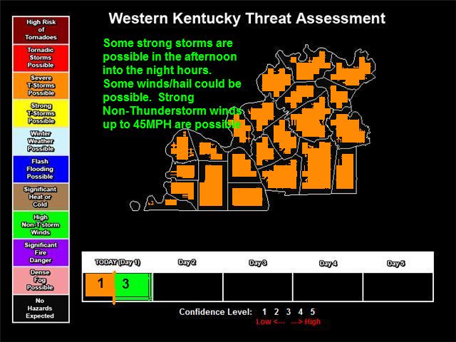
Lake Day 3 out of 5
Lake day of 3 out of 5 for today May 30th, and tom. May 31st.
Scattered to widespread thunderstorms remain for today and tomorrow. Today will still be scattered, so it will not be a total washout, tom. may be a little more of a washout but still not a total ruined lake day.
Scattered to widespread thunderstorms remain for today and tomorrow. Today will still be scattered, so it will not be a total washout, tom. may be a little more of a washout but still not a total ruined lake day.
Friday, May 28, 2010
Damage Survey for Marshall County
80 MPH micro-burst from one of the summer time storms that hit yesterday.
http://www.crh.noaa.gov/news/display_cmsstory.php?wfo=pah&storyid=53037&source=0
http://www.crh.noaa.gov/news/display_cmsstory.php?wfo=pah&storyid=53037&source=0
Lake Day 3 out of 5 for Saturday May 29th
Tomorrow is a 3 out of 5 Lake Day, but a little system will move across the south and cause some scattered thunderstorms across the Land Between the Lakes areas esp. TN part. Storms will be non-severe, but could contain locally heavy rain, and a lightning threat. If you hear thunder, and your on the lake your urged to seek shelter to prevent being struck by Lightning till the storm is over.
Remember a 3 out of 5 is not a lost lake day. It means that there is a chance of a hazard(for tom. lightning), and to exercise caution when going out to the lakes. Still go out there and have fun, just watch for any lightning threat that may form in the afternoon or evening hours.
A band of thunderstorms is moving across parts of the lakes from New Concord to Trigg/Stewart County line south. Although non-severe lightning is a real threat for boaters and swimmers. More thunderstorms may move across Muhlenberg, Christian, Todd, and Trigg Counties before coverage starts to decrease as we lose daytime heating.
4 out of 5 lake day today for KY side. 3 out of 5 for TN side. This is for May 28th 2010 today. Scattered thunderstorms will form today,it will not be a washout,but if you hear thunder, then your close enough to get struck by lightning. In the TN side of the lakes the coverage may be a little greater, but still will ...not be a total washout so anyone going to the lake enjoy. Lake Malone is also a 4 out of 5 as well.
Thursday, May 27, 2010
93 years ago. Great Purchase Area Outbreak
Posted from an old Myspace blog. My Spelling and typing wasn't up to par in 07, so there are several grammar, and even a few misspellings.
Also since this 93 years old little is known about this, so really all I had to go by was tornado databases from NWS Memphis, Nashville, and Paducah.
THE MOST DEADLIST TORNADO IN THE JACKSON PURCHASE AREA 67 DEATHS 345 INJURIES (65 IN WESTERN KENTUCKY) lets start with this tornado this was an F-4. To prevent confusion we are going use the original scale this affected FULTON,HICKMAN,GRAVES counties in western Kentucky in our area. This tornado started in Lake County Tennessee in extreme northwestern Tennessee. This storm was the most powerful and deadliest tornado on the day of May 27th 1917 and the deadliest for our area and one of our more deadlier severe weather death tolls. The tornado formed in northwestern tennessee near Tiptonville Tennessee around 4pm then crossed Fulton County about 7 miles WSW of Hickman Ky then with an southwestern to northeastern movement struck the county seat of Hickman directly where it was made a disaster area, and F-4 damage was done as the tornado crossed this area Fulton County and the city of Hickman Ky suffered some of the worst losses of the day F-4 means that several houses and structures were badly damaged and destroyed so Hickman packed a punch from this. Fulton County suffered an heavy death toll of 42 in Fulton County this tornado moved into Hickman County after it went though Fulton County also know that this area particularly Hickman and Fulton Counties were a little bit more populated than today because of the railroads booming in this time period. The tornado crossed Hickman county form the southwest corner about 6 or 7 miles southwest of Clinton Kentucky this tornado destroyed and heavily damaged the southeast city of Clinton Ky where a good deal of the 18 deaths in Hickman county occurred this tornado moved though eastern Hickman county and into western Graves County this storm struck north of the Fancy Farm area to near the small community of Dublin where 5 more people died. All and all 2 in extreme western Tennessee 42 deaths in Fulton County, 18 in Hickman County/Clinton Ky area, and 5 in rural Graves County. This is a F-4 tornado with a 800 mile wide path about as wide as the Christian County Ky tornado of Apr 2nd 2006. This path of the tornado was 50 miles long.
Also a deadly F2 occurred in Carlisle County on this same outbreak as well.
This outbreak was part of a sequence like May 2003 tornado sequence(there was a severe wx event every day, or nearly every day for a long period of time, usually greater than 5 day) that started in Late May and didn't die down till Early June of 1917. A deadly tornado hit Muhlenberg County in Early June 1917 from this same sequence.
Lake Day forecast for Friday the 28th
Storms will form today along the cold front, and be scattered, maybe a little more widespread than the last few days, but still no washout.
Good news is Friday there is limited chance of thunderstorms, but there is still a chance around 30% from east of Lake Barkley Lodge, and along and south of US 68. And around 20% for the rest of the lakes, and this also includes Lake Malone as well. This will not be a washout at all, but there could be an isolated storm in the afternoon, that people on the lake may need to be on the watch for. Overall the winds should be from the North, North-Northeast at about 6 to 9 mph so not really gusty. 20-30% chance of thunderstorms is also present, but overall a good day.
The Lake Day Rating for Friday May,28th,2010 is 4 out of 5.
Wednesday, May 26, 2010
Memorial Day Weekend is coming along
Isolated Thunderstorms again today. Isolated to scattered thunderstorms possible on Thursday/Friday. Saturday looks clear, and could even look like the perfect 5 out of 5 lake day, Sunday looks mostly clear, but there may be a stray showers, and Isolated to Scattered Thunderstorms Memorial Day. All in all no washout days
First Lake Day forecast will be for Friday. That will be given either sometime Tomorrow. morning, or Tomorrow. Night, but by tomorrow night I will get it out.
For now I would go with this(this can and may change)official will be the night before. The list below is preliminary
Fri- 4 out of 5
Sat- 5 out of 5
Sun- 4 out of 5
Mon- 4 out of 5
5 is best, 1 is worst.
Tuesday, May 25, 2010
Pre Summer Time Pop Corn Storms
http://www.crh.noaa.gov/news/display_cmsstory.php?wfo=pah&storyid=52862&source=0
Some storms reached strong to severe limits yesterday with some hail, and lightning shows.
Throughout the days up and until Friday isolated to scattered storms could form esp. in the afternoon hours.
Also starting on Thursday, for Memorial Day, and running until Labor Day Weekend will be the lake forecast. Which will be the forecast for any lakes, and rivers in the area, and will give a rating depending on several factors, that will determine whether it is a good lake day, a bad lake day, or just an okay lake day. One is the worst lake day, and Five is the best lake day according to the scale we will use. More on that when we do our first lake day forecast on Thursday Night. Also the lake day forecast will be given if possible the night before, and revised if needed. All weekends (Friday,Saturday, Sunday, and even Monday on holiday weekends) from Memorial Day until Labor Day will have a Lake Day forecast number.
Monday, May 24, 2010
Summer Time is coming,
Hot, Humid, with isolated thunderstorms. Most areas this week should stay dry, but some areas could get locally heavy rain, and a lot of lightning in the strongest storms.
Friday, May 21, 2010
North Trigg County T-storm Warning
http://forecast.weather.gov/wwamap/wwatxtget.php?cwa=pah&wwa=severe%20thunderstorm%20warning
Monday, May 17, 2010

Saturday, May 15, 2010
Link on yesterday's hail storms
http://www.crh.noaa.gov/news/display_cmsstory.php?wfo=pah&storyid=52436&source=0
Some hail and brief funnel across Calloway, Christian, and Todd Counties from yesterday's storms.
Friday, May 14, 2010
t-storm warning
T-Storm Warning for SE Christian/South Todd. A few pulse storms could produce hail and wind. Locations that could see some large hail: Fort Campbell North, Oak Grove, Pembroke, Trenton, Guthrie, and Elkton.
Saturday, May 8, 2010
Green River Update
http://water.weather.gov/ahps2/hydrograph.php?wfo=pah&gage=prdk2&view=1,1,1,1,1,1,1,1
Green River at Paradise is about to crest near 398.20 feet. This will be the 4th highest crest on record, and will also be greater than 97 and 08. Crest sometime today
http://water.weather.gov/ahps2/hydrograph.php?wfo=pah&gage=calk2&view=1,1,1,1,1,1,1,1
This area Green River at Calhoun will crest at 31.9 a little later in the week. This is only .1 feet away from flood stage, and already at this stage Lower Calhoun is experiencing flooding issues. Crest sometime Tuesday Morning
Turn around and do not drown.
Friday, May 7, 2010
Thursday, May 6, 2010
KY Emergency Management site
http://www.kyem.ky.gov/currentdisasters/
If you are, or you know anyone in these area that has damage it is important to pay attention to these directions.
If you are, or you know anyone in these area that has damage it is important to pay attention to these directions.
These KY Counties are eligible for federal aid.
The State of Kentucky selected these counties to be up for federal aid. The worst flooding was in Central KY, but major flooding occurred in Lyon/Livingston County, as the headwater from the Cumberland River flooded communities in that area. Also a Tornado/Flooding hit Fulton/Hickman Counties.
http://www.kyem.ky.gov/NR/rdonlyres/1EC3A5B3-1D40-4172-A6F2-FD14FF3B3960/0/Declarationmap4PMMay5.pdf
In Western KY:FULTON, HICKMAN, CARLISLE, LIVINGSTON, TRIGG, LYON, HOPKINS, CRITTENDEN, UNION, and MCLEAN
Wednesday, May 5, 2010
Hydro City
Moderate River Flood continues in the Ohio River, and Moderate to Major River Flooding along the Green River in West KY
http://water.weather.gov/ahps2/index.php?wfo=pah
http://water.weather.gov/ahps2/index.php?wfo=pah
Tuesday, May 4, 2010
River Flood Update
http://water.weather.gov/ahps2/hydrograph.php?wfo=lmk&gage=rchk2&view=1,1,1,1,1,1,1,1
Rochester
http://water.weather.gov/ahps2/hydrograph.php?wfo=pah&gage=calk2&view=1,1,1,1,1,1,1,1
Calhoun
Along Green River
http://water.weather.gov/ahps2/hydrograph.php?wfo=pah&gage=prdk2&view=1,1,1,1,1,1,1,1
Update on the Green River at Paradise
Flooding of minor to moderate levels also expected along the Ohio River, due to big time flooding along the Cumberland and Green Rivers.
Monday, May 3, 2010
Civil Emergency Message
KYC055-040700-

BULLETIN - EAS ACTIVATION REQUESTED
CIVIL EMERGENCY MESSAGE
CRITTENDEN COUNTY KY EMERGENCY MANAGEMENT
RELAYED BY NATIONAL WEATHER SERVICE PADUCAH KY
752 PM CDT MON MAY 3 2010

THE FOLLOWING MESSAGE IS TRANSMITTED AT THE REQUEST OF THE
CRITTENDEN COUNTY KY EMERGENCY MANAGEMENT.

RESIDENTS IN LOW LYING AREAS NEAR THE CUMBERLAND RIVER...
ESPECIALLY IN THE CITY OF DYCUSBURG...ARE ADVISED TO EVACUATE
IMMEDIATELY DUE TO RAPIDLY RISING WATER.

$$
Evacuations downstream from Cumberland River in West KY
Urgent update evacuations need to take place if you live in Western Crittenden, NW Lyon, NE Livingston County. Dycusburg KY you need to leave now major water releases on Barkley due to the TN flood are causing the Cumberland River to potenially flood Dycusburg and surrounding rural areas. This is a dangerous situation.
Fulton/Hickman County EF2 tornado
000
NOUS43 KPAH 031543
PNSPAH
ILZ075>078-080>094-INZ081-082-085>088-KYZ001>022-MOZ076-086-087-
100-107>112-114-032030-

PUBLIC INFORMATION STATEMENT
NATIONAL WEATHER SERVICE PADUCAH KY
1043 AM CDT MON MAY 3 2010

...DAMAGE SURVEY RESULTS FOR FULTON/HICKMAN COUNTIES IN
WESTERN KENTUCKY...

THE FOLLOWING IS THE *IN PROGRESS/INCOMPLETE* DAMAGE ASSESSMENT FOR
FULTON/HICKMAN COUNTIES COUNTY IN WESTERN KENTUCKY...

* EVENT DATE - SUNDAY MAY 2 2010

* EVENT TIME - 115 AM TO 125 AM CDT

* EVENT TYPE - EF2 TORNADO ***FOR THE TRACK SEGMENT BELOW***

* EVENT LOCATION - 2.5 MILES SOUTH SOUTHWEST OF CAYCE TO 5 MILES
SOUTHEAST OF CLINTON KY. ***THIS TRACK LIKELY EXTENDS BEYOND THIS
AND WILL BE SURVEYED FURTHER THIS WEEK***

* PEAK WIND - 115 MPH ***FOR THE TRACK SEGMENT ABOVE

* AVERAGE PATH WIDTH - RANGED FROM A FEW YARDS WIDE TO 400 YARDS

* PATH LENGTH - 8 MILES ***TRACK LIKELY EXTENDS BEYOND THIS AND
WILL BE SURVEYED FURTHER THIS WEEK***

* INJURIES - NONE

* FATALITIES - NONE

* DISCUSSION/DAMAGE - TORNADO TOUCHED DOWN NEAR ALEXANDER ROAD WITH
EF0 STRENGTH AND TRAVELED NORTHEAST MAINLY DAMAGING TREES. NEAR
HIGHWAY 924 IT INCREASED TO EF1 SCALE WITH SOME DAMAGE TO
OUTBUILDINGS AND MINOR HOUSE DAMAGE. ONE MOBILE HOME WAS MOVED A FEW
FEET AND THE ROOF TORN BACK. A BOAT ON A TRAILER WAS CHAINED TO A
POST AND WOUND UP ON ITS END DAMAGING THE BOAT. ANCHORED TV ANTENNAS
WERE PULLED OUT OF THE GROUND AND BENT. AS THE TORNADO MOVED INTO
HICKMAN COUNTY IT INTENSIFIED TO EF2 WHERE ALONG HIGHWAY 51 SEVERAL
POLE BARNS WERE DESTROYED OR DAMAGED. ONE BARN WAS OVER 100 FT LONG
AND HAD TELEPHONE POLES ANCHORED IN THE GROUND. MOST OF THE POLES
WERE SNAPPED HOWEVER...A FEW WERE PULLED UP...ONE WAS THROWN
APPROXIMATELY 50 YARDS. LARGE TREES UPROOTED OR SNAPPED. MINOR HOUSE
DAMAGE ALSO OCCURRED HERE.

SURVEYOR...SPODEN

$$
Christian County EF2
000
NOUS43 KPAH 030229
PNSPAH
ILZ075>078-080>094-INZ081-082-085>088-KYZ001>022-MOZ076-086-087-
100-107>112-114-030430-

PUBLIC INFORMATION STATEMENT
NATIONAL WEATHER SERVICE PADUCAH KY
929 PM CDT SUN MAY 2 2010

...DAMAGE SURVEY RESULTS FOR NORTHERN CHRISTIAN COUNTY IN WESTERN
KENTUCKY...

THE FOLLOWING IS THE *IN PROGRESS/INCOMPLETE* DAMAGE ASSESSMENT
FOR NORTHERN CHRISTIAN COUNTY IN WESTERN KENTUCKY...

* EVENT DATE - SUNDAY MAY 2 2010

* EVENT TIME - 249 AM TO 300 AM CDT

* EVENT TYPE - EF2 TORNADO ***FOR THE TRACK SEGMENT BELOW***

* EVENT LOCATION - 7 MILES WEST OF CROFTON KY TO 6 MILES NORTH OF
 CROFTON KY. ***TRACK LIKELY EXTENDS BEYOND THIS AND WILL BE
 SURVEYED FURTHER THIS WEEK ONCE WATER RECEDES FROM FLOODED
 ROADS***

* PEAK WIND - 120 MPH ***FOR THE TRACK SEGMENT ABOVE

* AVERAGE PATH WIDTH - 275 YARDS

* PATH LENGTH - 9 MILES ***TRACK LIKELY EXTENDS BEYOND THIS AND
 WILL BE SURVEYED FURTHER THIS WEEK ONCE WATER RECEDES FROM
 FLOODED ROADS***

* INJURIES - NONE

* FATALITIES - NONE

* DISCUSSION/DAMAGE - HIGHEST CONCENTRATION OF DAMAGE WAS ALONG
 POOLE MILL ROAD WEST OF CROFTON AND ALONG THE MANNINGTON LOOP
 NORTH OF CROFTON. 3 MOBILE HOMES WERE SEVERELY DAMAGED OR
 DESTROYED /UNOCCUPIED/ ON POOLE MILL ROAD AND ADAMS STORE ROAD.
 ON MANNINGTON LOOP...2 MOBILE HOMES SUFFERED MODERATE TO MAJOR
 DAMAGE AND A GARAGE WAS LEVELED. SEVERAL BARNS SUFFERED MINOR TO
 MODERATE DAMAGE. HUNDREDS OF TREES WERE UPROOTED OR SNAPPED...
 PARTICULARLY ON MANNINGTON LOOP AND U.S. HIGHWAY 41.

SURVEYORS...SHANKLIN/CHRISTIAN COUNTY EM SPOTTERS NETWORK

$$
Update on River Flooding
Some river flooding issues are being realized. Along the Green River in Calhoun, Paradise, and Rochester KY. Also flooding is being watched along the Ohio River, as the severe and potentially historic river flooding will move into the Ohio River. Several secondary roads are still flooded in Christian County because the rivers in that county are tributaries to the Cumberland that is flooding in Mid TN.
THE GREEN RIVER
Some Flood Levels
The Green River At Paradise is 389.6 Feet. Flood Stage is 380 feet the Green River is expected to rise to 396.9 feet on Thursday Afternoon before falling. This is a major flood.
The Green River at Calhoun is at 24.0 Feet. Flood Stage is 23 feet, and it is projected to crest near 31.0 feet with additional rises cannot be ruled out, this is near Major Flood Stage, and several acres of farmlands and roads can be flooded.
The Green River at Rochester is at 21.5 Feet. Moderate Flooding is in the forecast, and is projected to near 28.8 feet on Friday Morning.
Right now we are not expected 1997 levels along the Green River, but we could see some damage, and roads near the river could be impassable for days.
Sunday, May 2, 2010
Special Weather Statement from NWS Paducah
SPECIAL WEATHER STATEMENT
NATIONAL WEATHER SERVICE PADUCAH KY
406 PM CDT SUN MAY 2 2010

ILZ092>094-KYZ003>005-007>009-011-012-MOZ112-031400-
ALEXANDER-PULASKI-MASSAC-CARLISLE-BALLARD-MCCRACKEN-LIVINGSTON-
MARSHALL-CALLOWAY-LYON-TRIGG-MISSISSIPPI-
INCLUDING THE CITIES OF...CAIRO...MOUND CITY...METROPOLIS...
BARDWELL...WICKLIFFE...PADUCAH...SMITHLAND...BENTON...MURRAY...
EDDYVILLE...CADIZ...CHARLESTON
406 PM CDT SUN MAY 2 2010

...INCREASED RELEASES ON AREA LAKES...

DUE TO MAJOR AND EVEN RECORD FLOODING IN TENNESSEE...THROUGHOUT THE
CUMBERLAND AND TENNESEE RIVER VALLEYS...RELEASES OUT OF KENTUCKY AND
BARKLEY LAKES WILL INCREASE SHARPLY OVER THE NEXT 12 TO 24 HOURS.
RELEASES OUT OF BARKLEY DAM ARE EXPECTED TO RISE FROM 77,000 CUBIC
FEET PER SECOND /CFS/ TODAY TO AROUND 230,000 CFS BY MONDAY.
KENTUCKY DAM WILL INCREASE FROM 140,000 CFS TO AROUND 250,000 CFS BY
TOMORROW MORNING.

PERSONS IMMEDIATELY DOWNSTREAM OF THESE DAMS SHOULD PREPARE FOR
HIGHER WATER IMMEDIATELY.

SHARP RISES ON THE LOWER OHIO RIVER ARE ALSO EXPECTED AS A RESULT OF
THESE RELEASES. PLEASE REFER TO THE LATEST WARNINGS AND STATEMENTS
FOR THE LATEST INFORMATION.
Major Flooding expected along Green River at Paradise.
http://water.weather.gov/ahps2/hydrograph.php?wfo=pah&gage=prdk2&view=1,1,1,1,1,1,1,1
Storm Report Hopkins County.
05/02/2010 0830 am
Madisonville, Hopkins County.
Flash flood, reported by dept of highways.
US 62 closed between mile markers 16 and 18 due to high
water. US 41 closed between mile markers 16 and 17.
Several other seconary roads closed through the County
Madisonville, Hopkins County.
Flash flood, reported by dept of highways.
US 62 closed between mile markers 16 and 18 due to high
water. US 41 closed between mile markers 16 and 17.
Several other seconary roads closed through the County
Flood Update
The heavier rain in West KY is moving out, a half inch to near an inch in SE Christian and Todd is expected. Several road closures across Western Kentucky. Parts of US 45 is closed in Mayfield, 2 feet of water near homes in Princeton. Several road closures in Christian, Calloway, Trigg, Todd, Hopkins, Lyon, Muhlenberg, Mclean, Henderson, and Daviess County. If your not sure roads are open stay at home.
Mayfield Storm Report
05/02/2010 0830 am Mayfield, Graves County. Flash flood, reported by dept of highways. Countywide Road closures. US Hwy 45 closed between mile marker one and two with water over Road. KY 1124 between mile marker zero and one closed due to washed out cross drain.
http://forecast.weather.gov/wwamap/wwatxtget.php?cwa=pah&wwa=flash%20flood%20warning
Flash Flood Warnings for West KY till 6:15am road closures have been reported to the NWS be careful.
TORNADO WARNING
KYC033-047-107-143-221-020715-
/O.NEW.KPAH.TO.W.0024.100502T0639Z-100502T0715Z/

BULLETIN - EAS ACTIVATION REQUESTED
TORNADO WARNING
NATIONAL WEATHER SERVICE PADUCAH KY
139 AM CDT SUN MAY 2 2010

THE NATIONAL WEATHER SERVICE IN PADUCAH HAS ISSUED A

* TORNADO WARNING FOR...
 CALDWELL COUNTY IN WESTERN KENTUCKY...
 NORTHWESTERN CHRISTIAN COUNTY IN WESTERN KENTUCKY...
 WESTERN HOPKINS COUNTY IN WESTERN KENTUCKY...
 EAST CENTRAL LYON COUNTY IN WESTERN KENTUCKY...
 NORTHEASTERN TRIGG COUNTY IN WESTERN KENTUCKY...

* UNTIL 215 AM CDT.

* AT 135 AM CDT...NATIONAL WEATHER SERVICE DOPPLER RADAR DETECTED A
 SEVERE THUNDERSTORM CAPABLE OF PRODUCING A TORNADO 10 MILES
SOUTHWEST OF PRINCETON...OR 8 MILES SOUTHEAST OF EDDYVILLE...MOVING
NORTHEAST AT 55 MPH. THIS CIRCULATION WILL PASS OVER I-24 BY 145 AM.

* LOCATIONS IMPACTED...
 PRINCETON AND COBB BY 145 AM CDT...
 DAWSON SPRINGS AND OLNEY BY 155 AM CDT...
 CROFTON BY 200 AM CDT...
 EARLINGTON BY 210 AM CDT...

PRECAUTIONARY/PREPAREDNESS ACTIONS...

ABOUT HALF OF TORNADO DEATHS OCCUR IN MOBILE HOMES. IF YOU ARE IN ONE
NOW...MOVE IMMEDIATELY TO A MORE SUBSTANTIAL SHELTER SUCH AS A NEARBY
HOME.

&&

LAT...LON 3742 8754 3704 8746 3688 8796 3704 8808
TIME...MOT...LOC 0638Z 230DEG 48KT 3701 8794

$$
PS
Tornado Warning for East Lyon, Caldwell Critteneden County KY
http://forecast.weather.gov/showsigwx.php?warnzone=KYZ013&warncounty=KYC033&firewxzone=KYZ013&local_place1=3+Miles+SE+Fredonia+KY&product1=Tornado+Warning
Saturday, May 1, 2010
Two areas of storms
Two areas of storms appear to threaten to West KY. First is the hailers across Hopkins, Mclean,Muhlenberg County. These storms have produced golf ball sized hail. Those are part of storms that could cause some flooding, and more severe weather as they move from Mid TN into West KY.
Another area is a bow echo approaching the far west ky area. There is a confirmed tornado in the TN side of the storm. That storm may move towards Fulton/Mayfield KY area and will have to be watched.
Another area is a bow echo approaching the far west ky area. There is a confirmed tornado in the TN side of the storm. That storm may move towards Fulton/Mayfield KY area and will have to be watched.
Update: A Big time event is continuing across West KY and Mid TN. The situation is becoming a little more dire as some of the storms are quite severe, and are moving over flooded areas. One supercell is moving towards the Franklin TN area. Very large hail golfball size or bigger is possible in NW Mid TN and SW and South Central KY.
Two forms areas of severe storms are concerns for tonight into early tomm. Mainly from 11pm-6:30am. One is the cluster of the supercells in East Arkansas will move into SW KY, West Mid TN overnight. Another is a few storms that could rotate may form in a boundary as it moves across West and SW Mid TN. Storms could produce Flooding, Hail, Damaging Winds, and Tornadoes.
http://radar.weather.gov/radar_lite.php?rid=ohx&product=NTP&loop=no
Radar map for Mid TN.
Radar map for Mid TN.
Watch out for 3 to 5 inches of more rain locally 7 for the rest of tonight, and tomorrow to add to the 4 to 13 inches of rain already. This is predicted from a Parsons to Paris TN to Murray KY, and south of Webster and Mclean Counties. Some areas by the time all set is done early Monday in South Central KY and Mid T...N could have 7 to 19 inches of rain from Fri Night to Monday morning.
Update on Map

Normal Tornadic Storm Index of 3 out of 5. All of West KY is now under a Moderate Risk. With a High Risk back in Arkansas and West Tennessee.
Severe/Flood Outbreak possible

Some storms esp. later on this evening may produce flash flooding, large hail, damaging winds, and tornadoes.

Tornado Warning for Christian and NW and North Todd Counties. Till 4:30 Pembroke, Hopkinsville, Pilot Rock area are in the path. Still doppler indicated so wind is probably the main threat, with a chance of a brief tornado spinup http://forecast.weather.gov/showsigwx.php?warnzone=KYZ022&warncounty=KYC219&firewxzone=KYZ022&local_place1=Allegre+KY&product1=Tornado+Warning
Tornado Warning for Calloway and Trigg
TORNADO WARNING
KYC035-221-010830-
/O.NEW.KPAH.TO.W.0013.100501T0757Z-100501T0830Z/

BULLETIN - EAS ACTIVATION REQUESTED
TORNADO WARNING
NATIONAL WEATHER SERVICE PADUCAH KY
257 AM CDT SAT MAY 1 2010

THE NATIONAL WEATHER SERVICE IN PADUCAH HAS ISSUED A

* TORNADO WARNING FOR...
 EASTERN CALLOWAY COUNTY IN WESTERN KENTUCKY...
 SOUTHERN TRIGG COUNTY IN WESTERN KENTUCKY...

* UNTIL 330 AM CDT.

* AT 255 AM CDT...NATIONAL WEATHER SERVICE DOPPLER RADAR DETECTED A
 SEVERE THUNDERSTORM CAPABLE OF PRODUCING A TORNADO 18 MILES
 SOUTHWEST OF CANTON...OR 7 MILES EAST OF MURRAY....MOVING NORTHEAST
 AT 50 MPH.

* LOCATIONS IMPACTED...
 CANTON BY 315 AM CDT...

PRECAUTIONARY/PREPAREDNESS ACTIONS...

NOW IS THE TIME TO IMPLEMENT YOUR TORNADO PLAN OF ACTION. SEEK
SHELTER INDOORS IN A BASEMENT...OR IN AN INTERIOR ROOM ON THE LOWEST
FLOOR OF A HOME OR BUILDING.

&&

LAT...LON 3669 8825 3687 8786 3668 8774 3664 8786
     3667 8788 3667 8806 3657 8804 3652 8816
TIME...MOT...LOC 0757Z 243DEG 42KT 3662 8817

$$
MDT risk of severe wx and flood event
MDT Risk of Severe Weather along with potential major flash flood threat. This could be a rocky night for anyone who is hosting any local prom or local events.
Subscribe to:
Posts (Atom)


